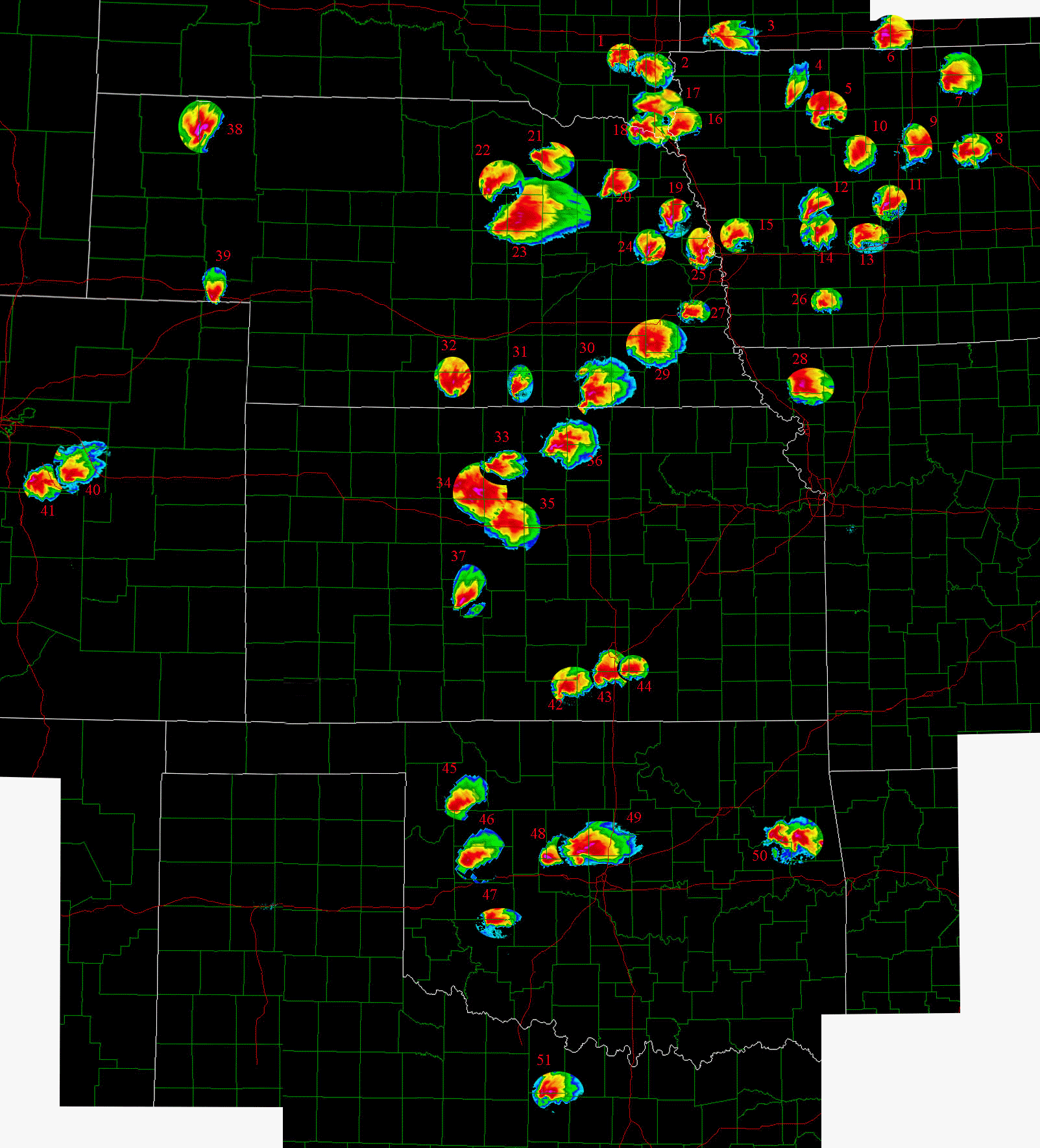
*I made this in 2004 from archived radar. I'm not messing with it anymore but recently re-uploaded it.*
These are different supercells from 2004, none of them are the same supercell twice. It's got a lot of the bigger events on there but a lot left off. Some cases there wasn't much of any radar data available.
1: Tornadic Supercell 5-28
2: Supercell 7-31
3: Tornadic Supercell 7-31
4: Multiple Tornado Producing Supercell 6-11
5: Bradgate IA Tornadic Supercell 5-21
6: Warm Front Supercell 4-17
7: Warm Front Supercell 4-17
8: Tornadic Supercell 5-21
9: Tornadic Supercell 5-21
10: Ft. Dodge IA Tornadic Supercell 6-11
11: One of many Tornadic Supercells 5-22
12: One of many Tornadic Supercells 5-22
13: One of many Tornadic Supercells 5-22
14: One of many Tornadic Supercells 5-22
15: One of many Tornadic Supercells 5-22
16: Possible Tornadic Supercell 5-21
17: Stationary Supercell, non-tornadic 5-9 nw of Sioux City should be moved south between the 2 other supercells
18: Amazing Supercell 5-28
19: Storm at 4:00 am 6-14
20: Tornadic Supercell 5-21
21: Tornadic Supercell 7-15
22: Holt. Co. Tornadic Supercell 5-16
23: Extremely Large Tornadic Supercell-7-12- 2 tornadoes occuring during this radar image with large tornado wrapping in rain
24: Non-tornadic Supercell 5-22
25: Non-tornadic Supercell 5-22 Froms ahead of previous supercell
26: Non-tornadic Outflow Dominant Supercell 5-17
27: "Big" Torandic Supercell Near Alvo Nebraska 6-13...amazing how small this was on radar
28: Tornadic Supercell 5-24....I believe this was also the storm that produced 6 inch diameter hail
29: Hallam NE Violent Torandic Supercell 5-22 just outside the town to the west in this scan
30: Prolific Tornadic Supercell 5-24
31: Tornadic Supercell 6-10 Hebron NE....the one in the amazing photos taken by Chris Gulickson and Doug Raflik
32: Another Tornadic Supercell from 5-22....near Alma NE at this time frame
33: Supercell 5-21
34: NW flow Toradic Supercell 7-7
35: NW flow Toradic Supercell 7-7
36: NW flow Toradic Supercell 7-7
37: Tornadic Supercell 3-27
38: Very Interesting Supercell 7-8...long lived strong couplet near center of the spiral banding
39: Tornadic Supercell 6-10
40: Tornadic Supercell 5-10 Elbert Co. CO
41: Supercell 8-9 (may of been tornadic I am not sure) It belongs right where the Elbert Supercell is sitting.
42: Tornadic Supercell 5-12
43: Tornadic Supercell 5-29
44: Torandic Supercell 6-12
45: Tornadic Supercell 3-27 near Vici....via ICT radar(no other data available)
46: Torandic Supercell 3-27 (not during this radar image, but after I believe) ....via ICT radar(no other data available)
47: Supercell 5-12
48: Supercell 3-27 during the evening, may of been tornadic(I think it was) ....via ICT radar(no other data available)
49: Tornadic Supercell 5-29
50: Cycling supercell 3-17 (probably not the best scan)
51: Supercell 6-1


