Joplin Missouri Tornado - May 22, 2011
The Joplin tornado took the lives of 158 people, the most from a single tornado since the 1940s. Devastated the southern side of Joplin, becoming the costliest tornado in US history($2.95 Billion). When you hear of a tornado warning, sometimes they mean this, blocks wide of total destruction, crossing an entire city. Violence that is hard to comprehend.
Before And After
Here is a pretty massive before and after image I made. It will open in a new tab and is made draggable(after it fully loads). So after it all loads, you should be able to click and hold and drag it around. Then click the toggle option. I had it even larger but some browsers did not like it any larger. Also some mobile displays show it soft.
In a matter of minutes, vast sections of Joplin simply become unrecognizable. Just consider the change in tree coverage by looking at that. It would seem Joplin's damage path width is about as big as they get. So it is useful to look at and realize the distance needed to get out of the path, if that was required. The Greensburg Kansas tornado was stated as 1.7 miles wide, yet the real damage zone is much like Joplin's...6 blocks or so wide. These are the extreme end of tornado path widths.
Google Street View
It's hard to imagine what it must be like to have your city change like this. To go from lots of trees and limited viewing distance in most all neighborhoods, to wide unobstructed views. All the landmarks of a massive area gone. This from an area just northeast of the high school. The google car after images are from 2012. After looking at quite a lot of areas, it's amazing how much reconstruction had already been accomplished in the first year alone.
Storm Prediction Center Outlooks
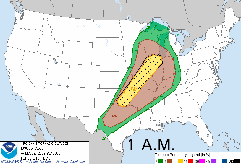
Text: 1 a.m. 8 a.m. 11:30 a.m. 3 p.m.
Here are the 4 daytime tornado probabilities issued from the SPC. The percentages are odds of a tornado within 25 miles of a point. The dashed/hatched area is outlooking the more likely regions any strong tornadoes would be. You can see from the first outlook at 1 a.m. Joplin is located in the center of a hatched area and remained there all day. As you'll see from the tornado reports, the number of tornadoes matched up pretty well with the higher and lower percent regions.
Tornado Reports
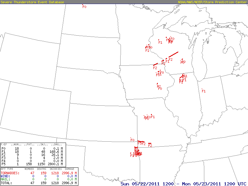
Here are the tornado tracks and ratings from the event. Joplin was given a rare EF5 rating. It's not that EF5 capable tornadoes are rare, it's just rare they encounter population centers. There are plenty of truly violent tornadoes every year, doing things very hard to even comprehend. Vehicles in Joplin were tossed several blocks. Some never located their vehicles again. Concrete was scoured away in some parking lots. Anchored 300lb parking blocks were removed and blown away. That is a heavy, low to the ground object, that doesn't have a massive surface area for the wind to act on. Winds that are capable of doing these things, becoming completely and utterly packed with all sort of objects, violently moving together. Winds that can take a vehicle and not just wrap it around one amazingly tough tree, but also shred and mangle the vehicle so only the frame is left twisted around in a knot.
Storm Prediction Center Tornado Watch - 1:30 p.m.
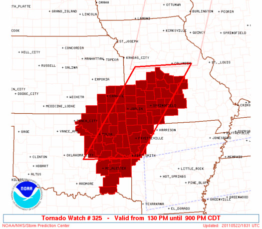
Text: Tornado Watch
A pretty early tornado watch gets issued at 1:30 as the dry line started to show signs of convection. The low level winds ahead of the dry line were fairly veered to the south-southwest however. The weaker low level shear gets mentioned in the mesoscale discussion that comes out first, before the watch. The upper/anvil level winds weren't very strong either. The early conditions just weren't that great for tornadoes yet.
Storm Prediction Center Mesoscale Discussions
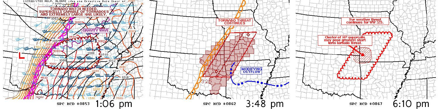
Here are the relevant MDs, one before the tornado watch and two during.
Note 2 things included on the graphics, perhaps hard to see(clicking the graphic makes it a bit bigger). Neither discussion really talks about them, but they are marked on the graphic. The first one shows a gravity wave, marked in a purple squiggly line that goes from sw to ne across the middle of Missouri. On satellite you'll see storms are firing on this boundary. Note that it trails right down towards Joplin. There are southerly winds south of it running into southwest winds north of it.
The second MD talking about the tornado watch has an outflow boundary marked on it in northern Arkansas. You can't overly see it on satellite or radar but you can see where storms are still firing on it. One can imagine how it might arc northwest on the back end of it.
Satellite
Here is the upper low and front responsible for all the severe weather. Note first the boundary across central Missouri and Illinois ahead of things producing convection. There's the gravity wave that trails towards the southeast Kansas storms. Then note the storms firing towards northwest Arkansas. There's an outflow boundary situated there. It is probably fairly diffuse west of there but I can sure imagine that it angles right towards Joplin.
Close In Satellite
Here is a closer in look with Joplin marked with the box. If you watch real close where the Arkansas storms are firing, you can see them doing so on the same sort of line. Then just west of them it appears that "line" curves and points northwest towards the northeast corner of Oklahoma. I'd say there are some effects of that boundary back towards Joplin. What is for sure is that just ahead of the dry line early, the winds were veered southwest, but that to the east, if they weren't already south, they soon would be.
Note that what moves over Joplin isn't a continuation of the convection in southeast Kansas but new storms marked by those new overshooting tops that pop up right before moving into southwest Missouri. It's much more clear on radar but figured I should point it out on here.
The storm popping up later and to the east in the better environment, made a massive difference. The old storm in southeast Kansas had been going for hours and did really very little. Then in nearly the same area you get a storm that pops up just ahead of it(but later on and more east in better low level orientation and flow) and that storm instantly becomes historically bad.
Significant Tornado Parameter

Here is the significant tornado parameter for 5pm from the SPC. It's only real use is just a way to show the potential of the environment fairly well with one image. It's not really an "arrow" that says something will happen right here. And you can gauge the situation just fine without looking at it. But it tends to quantify things well enough. It's just a combination of a few factors, essentially shear, instability and lcls(cloud base height). Those are rather high values but note how aligned they are with the mentioned outflow boundary location. Where an outflow boundary intersects a dry line is always going to be the/a potential hotspot if there is one. Not only is shear usually maximized there but as importantly so is convergence.
Radar
On this wide view of the radar you can see the boundary in Arkansas popping off storms as well as the dry line in the plains and the gravity wave across central Missouri into central Illinois. Just the orientation of the stuff popping off in Arkansas suggests to me effects of that outflow boundary are arcing up near Joplin, likely south a bit.
So the early stuff in Kansas continues for a couple hours, doing little more than some mild hail reports. It had pretty quickly grown into a cold outflow mess, with an extremely low tornado threat. But a couple storms pop up immediately ahead of the complex, taping into very unstable air still available there and also the better surface winds that are located there. Two of them in particular grow and rotate extremely rapidly. The second of which moves into Joplin.
It is really scary to realize this evolution is possible. It's just that the storm forms so so close to the safety of all the cold outflow already generated and that it also becomes so extremely violent and in such an amazingly short period of time. There's nothing more frightening out there to come across I don't think. So many ways to end up in the wrong location if one was dealing with these storms.
Warnings and Sirens
There was a tornado warning out for the north side of the city before the Joplin storm, for the storm before it that first gained strong rotation and a big hook. That was your more typical nothing happens tornado warning. Here is the breakdown of warnings and sirens.
5:09: First tornado warning for the north side of the city. 5:11: 3 minute sirens activated for that. 5:17: Second tornado warning, now for the Joplin storm, the south one that produces the Joplin tornado. 5:34 the tornado first touches down(17 minute lead time on warning). 5:38 second sounding of the sirens, now for the Joplin tornado. So while it had a 17 minute lead on the actual warning from the National Weather Service, it was a negative 4 minute siren activation.
Storm chaser Jeff Piotrowski's actions helped get that second siren going. He pulled up next to a cop on the north side of the city, yelling to get the sirens going. Sounds like this is what lead to the second siren going off finally. It's on National Geographic's "Witness: Joplin Tornado." Surely for some hearing the sirens sound a second time got them more concerned.
But the obvious problem is that warnings are only so useful when the tornado is capable of leveling a blocks wide path of houses that don't have basements(82% of Joplin didn't). And basements aren't always a completely safe location either. Trying to come up with a good answer on this is like a loop. If a house is going to be completely leveled, then trying to flee ahead of the tornado is likely a better option. That isn't the norm in tornado occurrences though and fleeing in those cases your house didn't end up leveled, would likely add far more risks than staying put. All you need is one tree to blow over on your car, simply from a storm. I'm always fearful of that one when in towns where there are usually no shortage of trees.
The other really big problem with fleeing ahead of a tornado is either stuck in traffic and get hit while in your car or possibly picking the wrong direction to try to escape. Joplin was originally heading east-northeast but then got sort of shoved right/southeast. Someone to the north that originally looked to be in the path could flee south and then have just put themselves in the path. One could try jumping east first perhaps. But look how things evolved here. New storms can pop up and spin like Joplin did. There are numerous potential issues when it comes to fleeing on some of these. Understanding a fair bit about storms and the setup can help a lot.
Close In Radar
The intervals between frames here is roughly 5 minutes. The red boxes are the tornado warnings as they come out. The first arrow to pop up points to the first lead storm that will attain a big hook and causes the first tornado warning for the city. The second arrow that pops up points to the Joplin storm just forming. It's best to just follow the storm after one arrow at a time and let it start over to watch the other. You can see how in advance the warnings come out for the city ahead of those hooks. The delay in sounding the sirens the second time is not good though.
This radar evolution is simply terrifying to me. I can't think of any other evolution that is more scary. Fast forming from nothing, on a city and also there's other storms all over the place already, adding more rain to the picture. It's just the speed and the violence that it does it and the fact it is narrowly ahead of a big blob of cold outflow generated by the now hours old storms in southeast Kansas. Cold outflow will undercut storms and choke off tornado chances typically.
A storm chasing tour group, a very experienced one(decades), almost got hit in town. Other than a gas station not letting them stop to take breaks and get stuff(before the 2nd hook), then power going out and letting the traffic lights stop/open up, deciding not to stop in a Home Depot to shelter, it was radar that alerted them and saved them. They reacted to the radar and fled south. And this is from very experienced people, looking at every single radar update the second they get it...and they only barely escaped. Even with their awareness and knowledge, this might have also ended differently had they just simply been moving south further west in town too. That is the thing on this one that is so terrifying. Even with a ton of storm experience, knowledge and data on hand, things can sneak up on you. It is of utmost importance to have an awareness of the local environment and consider the worst could unfold until that environment becomes a little less conductive.
The fist arrow storm making the big hook and tornado warning for the north side of the city, sure seems it was planning to do what the Joplin storm does, had the Joplin storm not started to run it over and rain on it. And the later storm south of the Joplin storms seems it was set on producing too but got too much interaction from other storms. Surely there is some form of that outflow boundary arcing through there those are crossing and getting ramped up low level shear from.


