Hurricane Katrina - August 23-31, 2005
Hurricane Katrina became the most costly US natural disaster and storm at over $100 billion. It was also the top 5 deadliest hurricane, with 1833 deaths, the vast majority being the elderly. While over the gulf it exploded into a violent 175mph category 5 hurricane, with a minimum central pressure reaching 902mb, the 7th lowest in the Atlantic on record. At landfall it had weakened to 125mph category 3, with a 920mb pressure at the time, the 3rd lowest landfalling pressure in the US. The storm surge had already been built up however and would inflict intense damage along the coast and help flood New Orleans. The storm surge along the Mississippi coastline was in the range of 26-28 feet, which is massive. In the New Orleans region it was 10-15 feet. A new record surge height of 27.8 feet at Pass Christian, Mississippi was set, topping the previous record of 22.8 feet there.
275,000 homes were damaged or destroyed by the storm, many of which were from the flooding in New Orleans. Several levees were breached in the city, along with a lot of overtopping, rapidly flooding the entire city, most of which lies below sea level by several feet. Up to 15-20 feet of water would cover 80% of the city. Many would be forced to seek shelter on their rooftops. The warning text included instructions to take something with into the attic...to cut through the roof if the waters got that high. Around 80% of the city had been evacuated due to the mandatory evacuation issued the day prior to landfall.
It was pretty shocking to load up Google Earth and go back in time and see these images from NOAA taken on the 31st of August, 2005, 2 days after landfall. You get some idea from the news that things are bad, but being able to "travel" over the land, really puts the scope of things into some perspective.
Video Guide/Flood Map
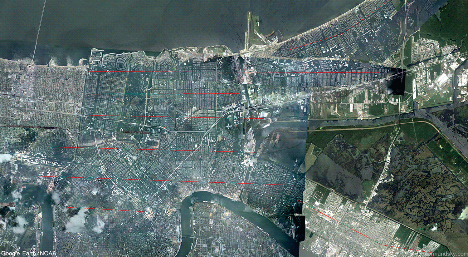
The red lines are the paths I made in there, making sure to at least not overlap the view. So nothing in the long video should be repeated at all. There's actually some decent gaps that are never covered between flight lines. So you get some idea here just how staggering the scale of flooding was. Sooo many houses.
Coastline Damage
The worst wind and storm surge would of course be right of the eyewall or to the east of New Orleans. Even though it weakens before landfall, that 175 cat 5 in the hours before had already built up a large wall of water moving towards the coast. The immediate coastline arcing over towards Biloxi was hammered by the surge.
Satellite Storm Evolution - Day and Night
The storm became a depression on the 23rd, a storm on the 24th and a category 1 hurricane as it made landfall in Florida. It then weakened back to storm over Florida. After entering the gulf it quickly became a category 2 on the 26th. Between then and the 28th it exploded into a violent 175mph, 902mb category 5.
Crossing Florida
Here's the radar from the morning of the 25th through the morning on the 26th. One interesting aspect of this historic hurricane is that the eye actually crosses directly over the National Hurricane Center in Miami as it crosses Florida.
August 28th - Category 5 - 175mph - 902mb
Once out over the warm gulf waters and light winds aloft, Katrina simply exploded into a monster storm on the 28th. This now frightening, 175mph category 5 storm, quickly set off multiple alarm bells for the southeast gulf coast. Not only were the prospects bad for below sea level New Orleans, but so would be anywhere right of the eye for a record breaking storm surge.
Powerful Eye Super Zoom
This zoomed in satellite is also from the 28th as it was peaking out. As this was going on, at 9:30 a.m. the mayor of New Orleans issues the mandatory evacuation of the city. Official landfall would be 6:10 a.m. the following day, so nearly 24 hours before that. Truly dire wording began to accompany the hurricane warning text now as well.
National Weather Service Warning Text
28th 10:11 am - Katrina Dire Warning Text
28th 4:13 pm - Katrina Dire Warning Text 2
29th 6:19 am - Katrina Dire Warning Text 3
29th 8:14 am - First Levee Breach
29th 11:40 am - Attic Axe or Hatchet Flood Warning
Most of the dire text was for extreme winds. I mean airborne light vehicles? Yikes. The storm weakened just before landfall and so this threat declined quite a lot. What that extreme wind of the day before and that morning had already done was get water moving in a big way. The record storm surge to be was set in motion. The storm surge along the immediate coastline to the east of the eye was devastating. Meanwhile of course the levee failures in New Orleans would cause the devastation there, also due to the storm surge. You had pretty perfect funneling conditions, jamming the surge right up into lake Ponchatrain. You not only had the general motion of the max surge jamming up in there, but then as the eye moved over and east you had strong northeast winds causing further motion of it back down towards the city from the lake.
Radar
New Orleans lies on the west/left side of where this eye moves. The eye heads right for the radar site, which goes out on the last frame of this loop. With this motion it isn't hard to imagine how the water from the gulf is getting jammed right up into the lake. That and how the populated coastline of Mississippi to the right of it would get the worst of the surge itself. For miles and miles that coastline was devastated.


