August 2, 2014 Geddes SD Supercell
Another good chase but again with probably more to type than images to post from it. For starters, this was a Storm Prediction Center "See Text" only day. I thought it had a bit more potential than that. There were some pretty good forecast soundings in a small region in northern NE, southern SD where some better mid-upper flow was in place, on the back side of a trough dropping across the northern plains. My biggest question on deciding if it was worth trying or not was moisture. There had yet to be much of any return flow, after some frontal passages that pushed the real stuff well south. The only thing the last few days had was good sun on all the corn....evapotranspiration. Several mornings had been producing fog. None of which I saw coming or was out on. I thought, well there may be enough moisture from just the evaporation effect by now, to hold onto a 60F or so. I'd take a 30 degree spread chase. 40 spreads and it is really damn hard to end up on anything worthwhile. 30 is a lot more reasonable, at least for structure.
I checked Omaha's morning sounding but it wasn't so hot. Topeka was better and a hint some moisture may have been slowly moving west then north through central NE on surface obs. I thought, what the heck, I'll give this a shot. It was a pretty obvious target otherwise. Weak low and triplepoint would setup in southern SD or northern NE. It was rather weak and not greatly defined or at least the warm front wasn't so much.
I first stop near Spencer NE and watch towers struggle well west on the surface trough that was slowly pushing east. Some higher based convection also fired to the south. The outflow off that stuff was troubling, as it would be so close to anything I'd get to fire on the surface trough. Then there were easterly winds up in SD, north of the warm front. It was actually pretty defined where it needed to be but the eastern extent was rather disorganized. Anyway, I could tell right where I needed a storm. North of the struggling towers, on up just into SD. At least at that point. But those towers just could never do much, all the while always looking like they were on their way to doing so. I wisely did not venture west to them. Likely almost an hour west. Instead I opt to drift up into SD.
I began to think the day was toast. I saw nothing promising out west. I had one tower I could see north of the warm front. I then noticed on radar a storm was north of I90, well north of the front. Hmm. I went east in southern SD ,watching my lone crappy tower. It eventually pulls me north. This was really my first give up of the day. I was in give up mode drifting east and decided to give the one tower a whirl. I go well north and see just how horribly small the base is. Knew it was a waste of time, just off how it was acting on radar prior. But getting to it was alarming lol. I give up again and head south and east.
After driving east quickly for a while, I see a new tower behind the one I just gave up on. Kept going and kept watching it. Finally it suckers me to turn around again. I knew there was little reason it would do any better than the other did. It did just the slightest bit better. I get to it and well it sucked too. Barely making an anvil bad. Plus another crappy tower went up behind it and rained on it, killing it quick. I was now up along I90 west of Mitchell. Thought, I'm now getting home 2 hours later than I would have if I kept going. The one north of I90 earlier was now to I90 and I could see it was amazingly pathetic. As was assumed the whole time based off how small it was on radar. So back home again I go for the 3rd time.
I'm going south on a rural highway south of I90 and noticed headlights behind me a good ways. They had to have just gotten off I90, as it was right there. I go by a house with a woman out washing her car. She looked like she was coming out to meet that car. It stopped there. I thought she got in, not sure. I then pulled over on a gravel road to look back at my crappy storm. Car goes by and it was a cop. I do a 3 point turn there and quickly leave and continue south as I didn't have data there. I get to the next highway and the cop had just pulled back north and stopped in the grass. I waved. He was on the radio as I went by. I turn east and soon see him getting on the highway behind me. Soon his lights were on. I was a little perplexed at that point. Thought, ok what exactly am I caught up in here lol. He has zero reason to be pulling me over. He walks up and I tell him I'm chasing and he was cool. Someone reported a suspicious car. Kind of amazed anyone bothers calling police over a few minutes of a car stopped on a road somewhere. Sure was never very long I was even stopped. Like give them a break, let it get at least a little more suspicious than that before bothering them. Oh no, a car is stopped on a gravel road near nothing.
While stopped talking to the cop I notice a couple new bases back to the west and northwest. I thought, well hell those actually look like legit bases. He even commented how he thought everything was small and how he didn't know they were going to get really big. I said yeah those actually look legit. Still didn't have any data, but what I could see it was an easy choice to again call off the drive home. Started driving west and getting mildly excited finally. It's amazing these did what they did so close to the others, which could do nothing. These new two had to be right along that trough now and well the triplepoint having moved east. The others either weren't moving, were moving slowly south or backbuilding and dying west. They just weren't moving south fast enough to get some inflow, given the weak surface winds. The storms had to move to be any good and these right away took off south. Was like, heck yeah, now we got a play.
Going west I get data and see them both go severe fast. I then hit a road closed sigh. Argh. Drop south there and eventually get to highway 281 and continue south. It was an easy choice to skip the north one of the pair and pick the southern one. Just a bit of a chore to get ahead of it, as it turned southwest and I was northeast of it. But not too bad.
South of Corsica I opt not to take the 3 mile east jog to continue south and instead plow onto the gravel roads. About destroyed my car on those gravel roads. Hit a big double dip deal and bounced hard. Springs bottomed out so hard. Bounced so much my one flip flop was half off my foot lol. Was certain it had to break something, but the car seemed good to go. I was amazed.
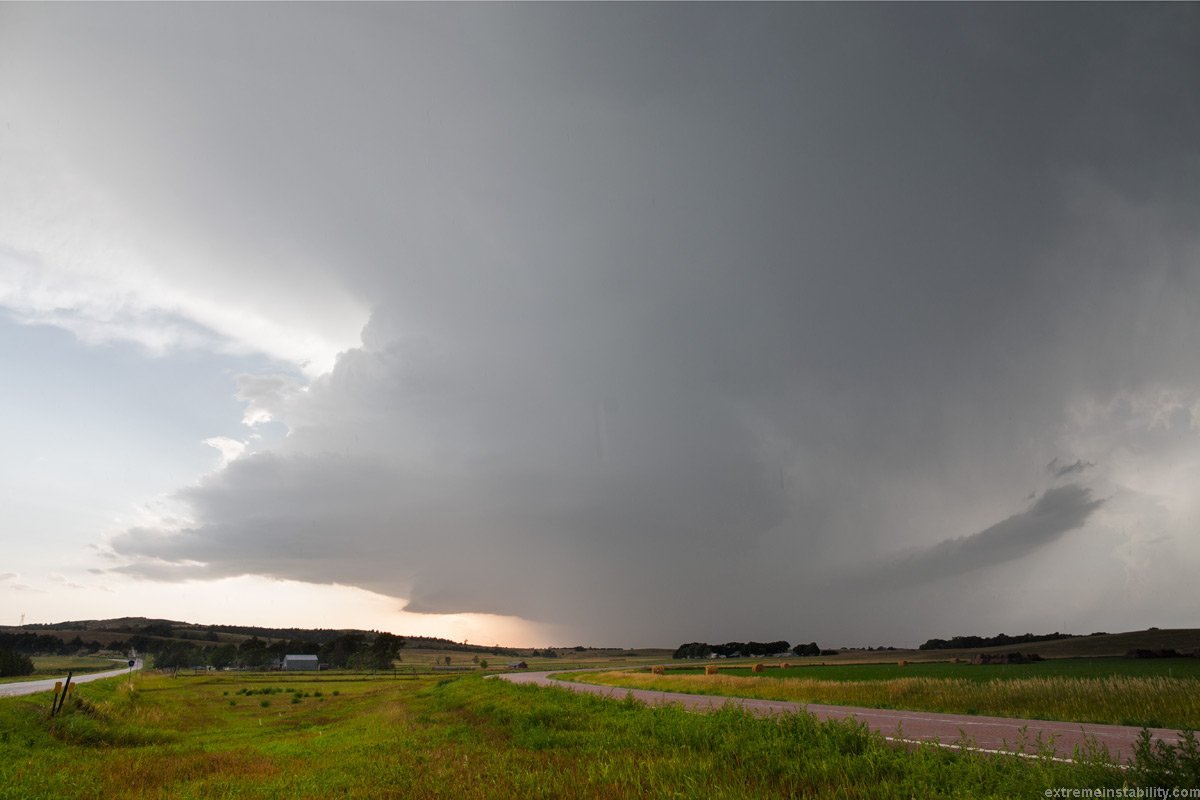
View of the supercell at Lake Andes. I could have just sat here for a few hours earlier and saved myself a lot of trouble and miles lol. It's hailing on me here. I'm sort of amazed the SPC never bothered with an MD for these. Wasn't much else going on. It was a pretty obvious target/region with some potential. It wouldn't be until they were dead an MD would be issued about how they should die an hour after sunset. Somewhere around now the thing is dropping 3.5 inch hail. Bigger than baseballs. Scott Currens was actually up here picking up his broke down SUV, that I guess had been up there since chasing in June lol. As in picking it up where the dang storm was! He found the 3.5 inch stones.
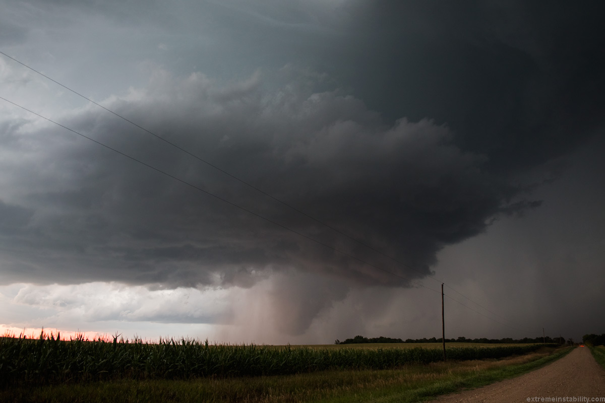
I'm now southwest of the dam. Ah it felt good to watch a nice supercell without anyone else around. I have a thing for southwest moving highly deviant supercells helping weaker side shear. I will see a setup that looks so-so and think, all that needs to happen is a storm go sw down a boundary. Seem some amazing storms that way in the summer. If this one had a bit more moisture I wonder what would have happened. It was cool how the sun was coloring the rain right now. I kept thinking, is that dirt.
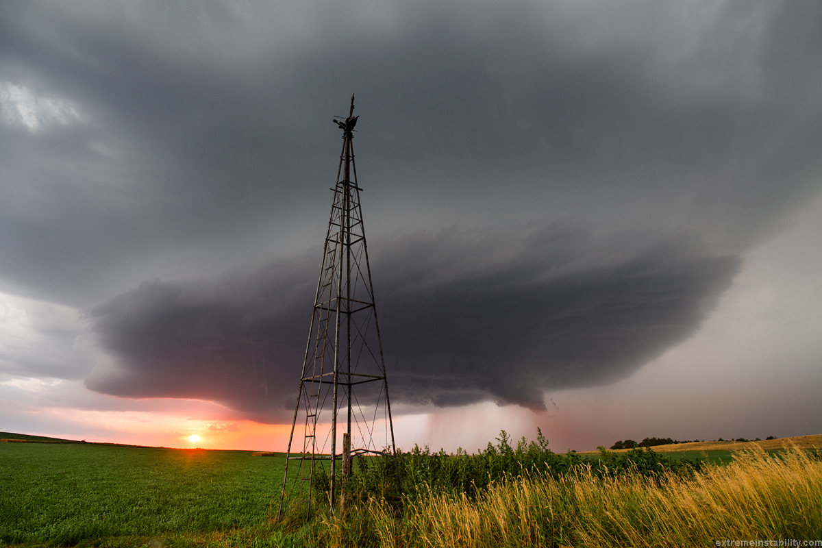
Ultrawide angle, 14mm full frame. Hailing with strong easterlies. It was pretty amazing feeling those winds ramp up after getting just southeast of the storm. The environmental winds were rather weak this day. It was all storm inflow making those winds. Convection goes up and gets blown off the top with some better winds aloft and the air just gets drawn in nearer the base. I kept thinking, this is going to kill this storm though. You don't want too much turning. You don't want to feed a storm air it is generating. Thought the way the winds were raging out of the east and this storm's core going so much to the southeast, that it would really ingest its rain cooled air. And you could tell that was likely an issue, even as much as it was going southwest. It had to go southwest or it wouldn't last at all. It really could have used some nicer southerlies. Change much of anything the slightest bit and I'm guessing it would have been a tornado producer.
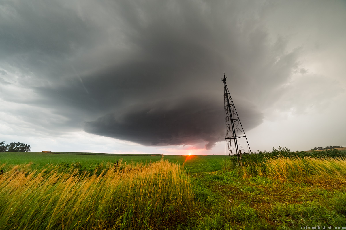
24mm full frame. Can see the hail bouncing.
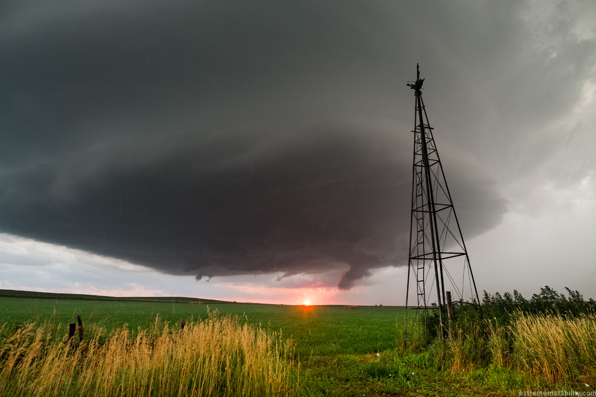
This is a bit later west of Spencer where I originally targeted. It really got wrapped up a couple times but the structure wasn't as hot. It would almost get it done then "bleh" would hit it. Seen plenty of storms act like that. Often they are ingesting their own stuff too much and get pulsy in that sense. That isn't a tornado. Guessing it gets to the point of producing, then as "bleh" hits it, it starts to wind down and momentum just sort of drags the condensation down. Hard to describe real well but easily recognized at the time when you've seen the evolution a few times. Cheesenado producers. Think about a storm getting a gulp of good air and being all robust. Then the winds feeding it more of the rain cooled air from that. Storm then gets to deal with a bunch of not so nice air. Perhaps it then produces less rain cooled air and gets a chance at a bigger gulp of better air. Least it is a pretty recognizable thing to see after a few chases.
August 2, 2014 Geddes SD Supercell


