June 16, 2010 Dupree South Dakota Tornadoes
This was just one of those days you don't want to go chasing far from home, but you go anyway. I had just chased the 9th, 10th, 11th, and 12th, adding 3 motel rooms to the year's expenses and plenty of miles/gas. The 9th sucked out in the NE panhandle. Lead early cell suckered me back east off crap down in CO, only for it to die. I go to my room in Ogallala early, only to see another supercell fire in eastern WY. At least I blew that off and didn't miss a ton in doing so. The 10th was an upslope day, but it also had better shear later on the southeast side of a boundary stuck through the Ogallala area. But this area was clouded over most of the day. Models insisted on firing it up though. Supercells fired early to the west but the moisture wasn't out there yet. I could see the moisture on satellite to my west and figured I could at least wait and see what happens till storms reached that line. Well better ones took over down near Denver, but I didn't bail for them and instead waited on my Ogallala boundary. Well the CO storm was structure of the year most likely and my boundary waited till dark to fire. I chased it east to North Platte stupidly, then drove back west to Ogallala to my room. The 11th comes around and looks damn similar to the day before. This time on the boundary east of the upslope play, I notice it had cooler 700mb temps and more sunshine this day. It again would have great shear later on. But, this deal cost me greatly the day before. So I jet down to eastern Colorado for the upslope. The Limon storm largely sucked and what happens further east in northwest Kansas on that boundary? A stationary beast of a supercell, great hooks and several tornado reports, all while not moving for 2-3 hours and NOT A SOUL on it. Spotter network shows chaser icons that choose to put themselves on there. Which is a lot. Everyone in Colorado basically. And not a one on that beast in KS. Where I was targeting much like the day before, but only not there like the day before now LOL. The whole year I've tried to pick and chose and nail on those I go on. I had held off for this stretch for a bit. Bam bam blew back to back days.
By the 16th...this account...I was rather frustrated. Hell after the screw up on the 10th I was ready to go home and look for a job. Had I not had the Ogallala motel a second night I would have just driven home and not even chased that 11th op. May as well have since I did blow that one too. At least the 12th was entertaining with the dog deal. This 16th of June was again annoyingly nowhere near home, like the entire year. Worse yet, it had some question marks like much of the year. Models were showing 25 knots of southwest 500mb flow. 30-35 if you were lucky. Getting 25 knots of mid-level flow to work is usually tricky. It can with strong and backed low levels and also with a storm going pretty deviant in motion. The one plus was a good upper jet, like 60+ knots. May 22 this year was similarly problematic with shear, only in that case it was so backed aloft and kind of west...with a strong cap. That storm that day was absurdly deviant on that boundary/warm front.
The 17th of June looked like a much better day and it would have been damn easy to skip this day for that closer to home op. Especially given recent frustrations and money and time, only a couple few days old. For whatever reason I just decided to go and see on this one, planning to get another motel and chase the 17th after it. I figured north of Rapid City, an 8 hour drive, but hoped for the warm front further east to some how come into play on my way there. A little of both happened, just not overly far northeast of Rapid City anyway.
On the way west through South Dakota you could see cu(cumulus) spreading north on the returning moisture. Half way across the state I could see what looked like a single tower at the northern edge of that returning cu. It sure wasn't much of a tower but it did look like something out there one could call a tower and for that it was interesting. I continue on and fire up Rapid City's radar. It wasn't too long and you could see tiny tiny returns popping off in the same location and going north. This was right along the warm front, which showed up clearly on surface obs. Soon it was obvious by the radar loop there was enhanced convergence right there. A while later SPC issued an MD for WY/MT/SD but this area was so close to the edge of that, it didn't seem it was really being outlooked by that. Then when the tornado watch came out it was again just barely in the thing. Just kind of one of those deals that doesn't make you commit any easier, when there are other targets further west yet. I'm rather certain I'd already committed by those however and was north bound from near Kadoka. You see consecutive blips popping off the same area, just get there soon.
Going north there I was reminded of the 24th of May, since it was the same area more wedge tornadoes were produced as I was 30 minutes too late. Actually the more I thought about that day, and me thinking I was too late to get north....that I wasn't too late. Storms that fired near me on the interstate then didn't move as fast north as I figured, slowing down as they crossed the front that day. So in a way this day was turning into redemption on the missed stationary KS beast on the 11th of June and those missed storms on the 24th of May in this same area. Just because this thing ends up not moving much like that KS one and producing great tornadoes in this same area as the 24th of May. I just don't want to think of how I'd have felt if I took the easy way out and stayed home this day I wasn't terribly interested in chasing.
I get to about Faith SD, south of there, and stop. There were storms lifting north of the front, taking on supercell characteristics but refusing to turn right. 25 knots of southwest mid-level flow and a storm lifting due north or northwest is just extremely unlikely to work out. It's moving away from its southeast inflow and trying to rain in it at the same time. It's just trying to use whatever is in place to the northwest.
I notice Bob Schafer leaving Rapid City on spotter network heading back east, surely to come up to this area. Eventually he shows up and stops to talk. These things dinked around that long to give him plenty of time to make it from there. About the same time a couple new towers go up just to our east. The closest of which looked quite intense with an early flanking line to the thing. The question was, ok, does this storm lifting north turn right before or after that east west highway up there out of Faith. Or dare one ask, on the highway? There aren't many roads up there. Get off the very few highways and you just don't have options. That alone is a big risk of even trying to chase these areas. Your chances of seeing greatness are just low.
As Bob and I talked I began to get that whole, I need to interrupt here and say I'm leaving right now. I eventually did. As I drove north to Faith I thought, damn it! Why do I talk to anyone before a chase is over. I will continue to talk even when I think it might be starting to cost me. It got a tornado warning as I drove east into it, or maybe it was as I still was going north to Faith. I then had to stop and get gas in Faith just to know I had a full tank. I'd just put $4 in at Kadoka to top off, but thought I'd better do it again. I then got going east fast. Soon rain from the storm overtook me, and very shortly after that some hail. This with about 10 minutes to go to get through it. Nothing but a blocked road was going to stop me from punching what little bit of the far north side of the core I'd have to punch. Meanwhile the storm to its northwest got a lot lower and nice looking. And a tornado warning too. I gave that thing no more look than what I did as I drove east through the lead one. It just had its death ticket signed by the one ahead of it, given the strong east-southeast inflow of the day. The lead one would eat its inflow and feed it its own outflow instead.
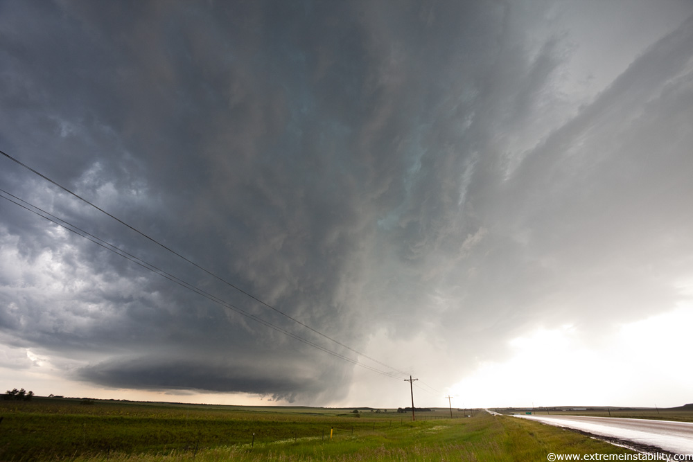
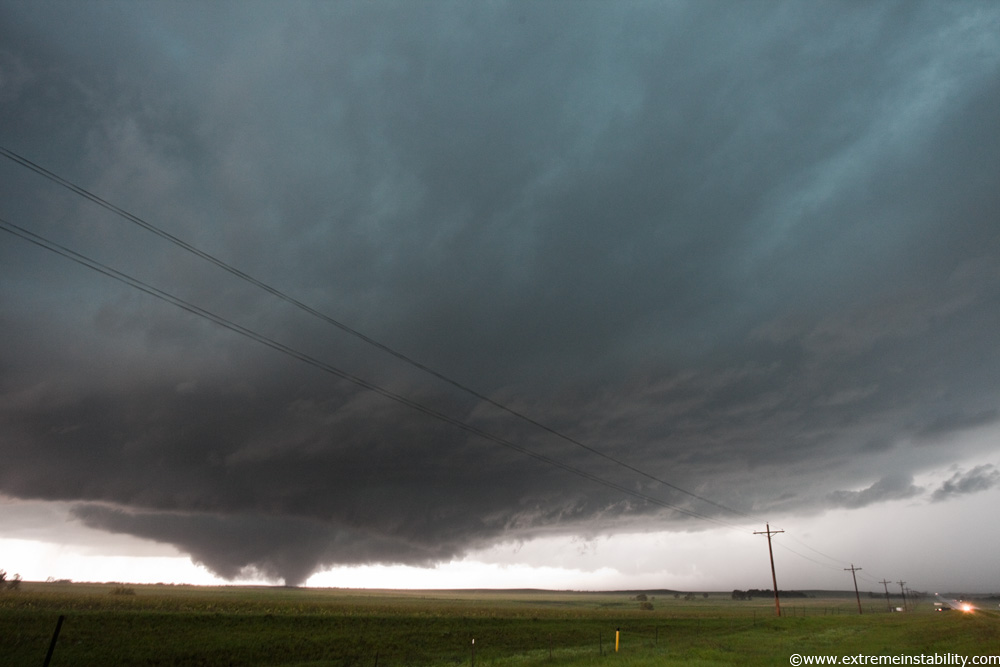
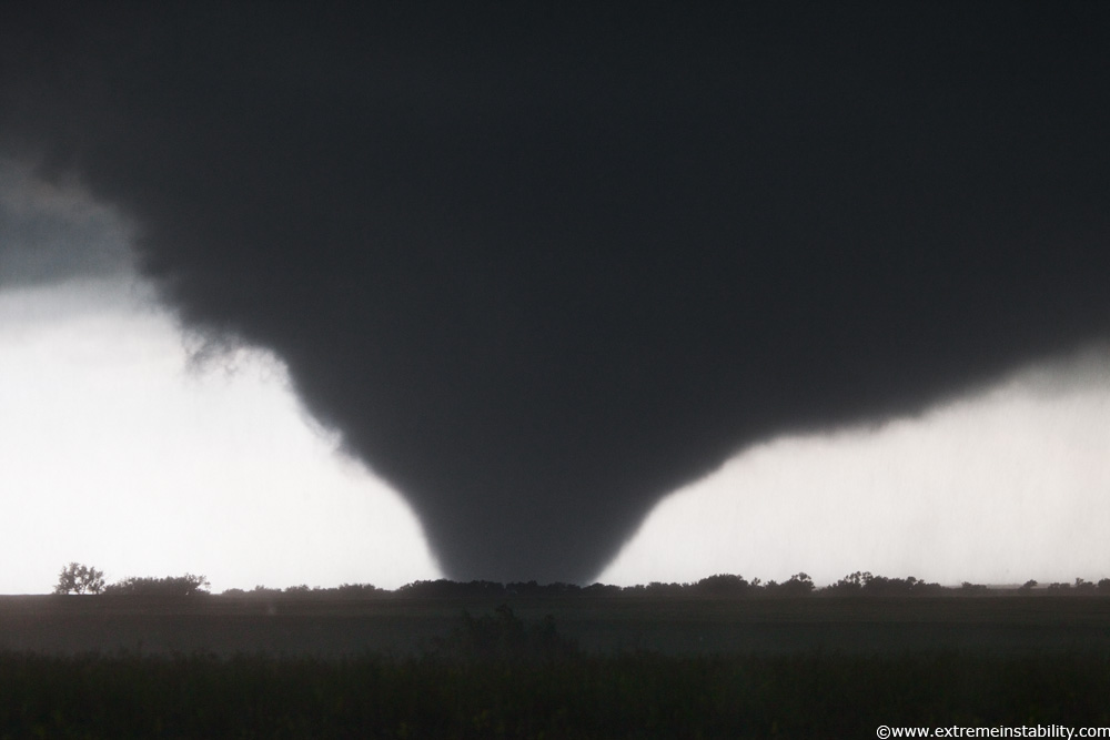
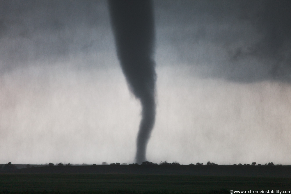
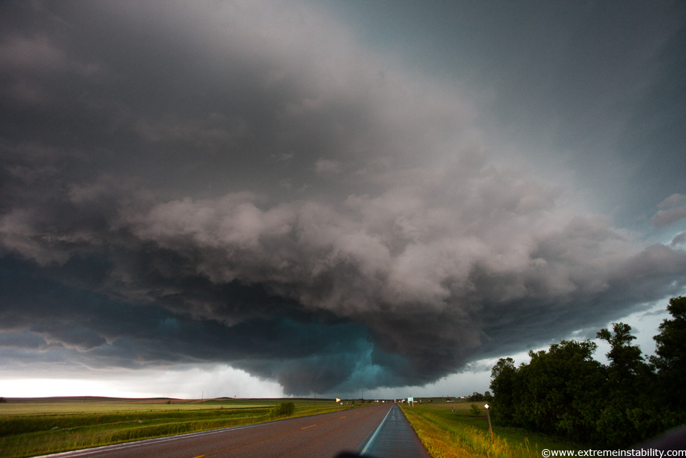
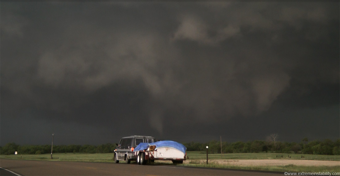
This shot was taken fairly soon after I was ahead of it, just west of Dupree. I did look for some better spots a bit but wasn't finding much. So I came to this pull off. 5:35 pm is the time on my camera here. See the shot below a bit that has a tornado with structure? (4th one down below this one above) The time on that shot says 6:25 pm. It's from this exact location above. The above one was taken at 17mm on a full frame camera. The tornado one was zoomed in some at 27mm. The storm hasn't gone anywhere in an hour. It had turned right and stopped before I got east of it. It was probably stopped there at about 5:00 pm. It was messed up to sit here this long watching a storm in the same spot go nowhere. It was more insane to watch it not become less of a supercell, but even more of one. A prolific tornado producer. That yellow pole is in both shots, but remember the one down below with the first wide angle view of the tornado is zoomed in some on that. It's all not about in the same spot an hour later, it's the same spot.
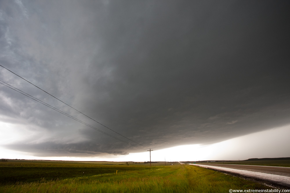
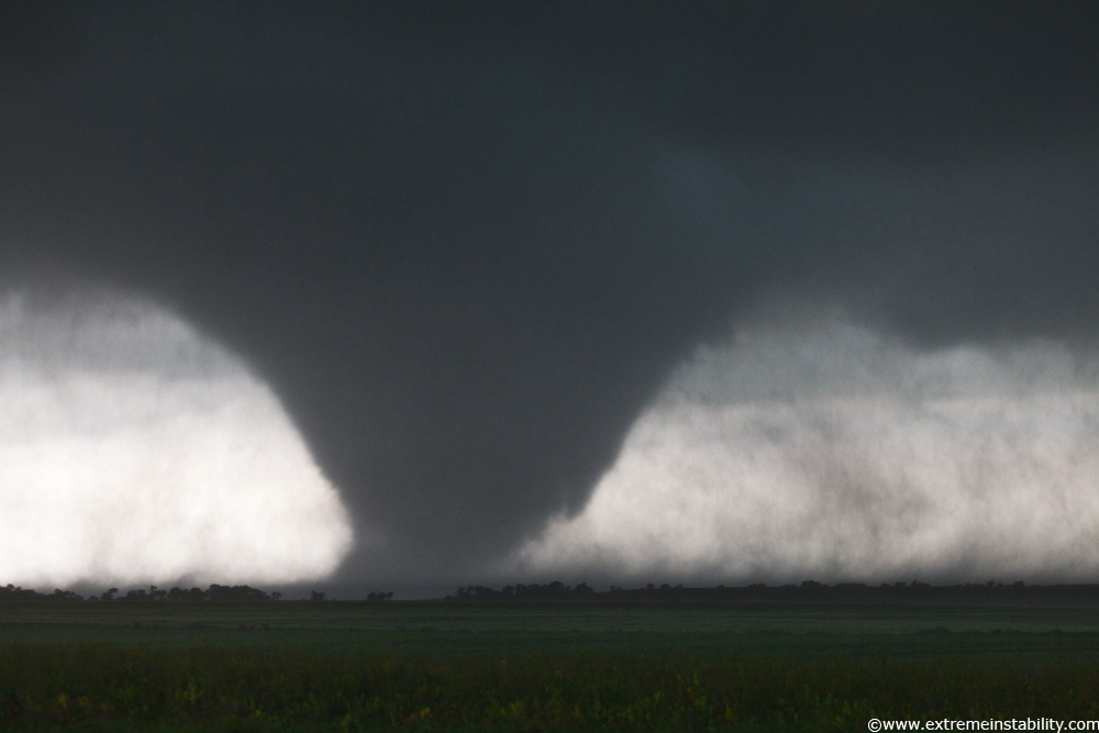
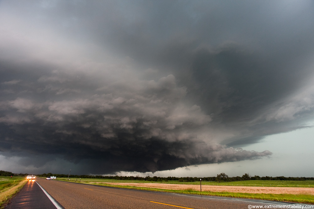
At one point a wide area of low clouds form along the forward flank precip. I was like damn what is happening now. Whatever it is it is happening rapidly.

Then a bit later that starts to clear up again showing the vault region and structure again.
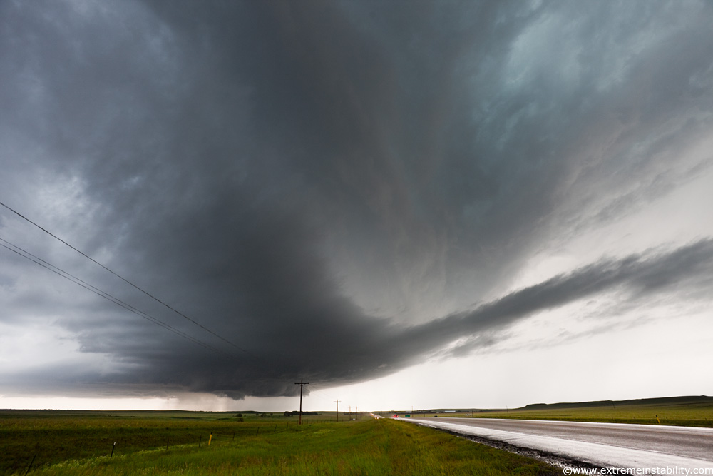
Around now a very intense and wild cloud to ground lightning barrage is unfolding. Bolts hitting right behind me to the east, to the southeast of that southern base area too, and in the core/vault area. And in front of me there. Bam, bam, bam, scary lightning activity. Went on for quite a while.
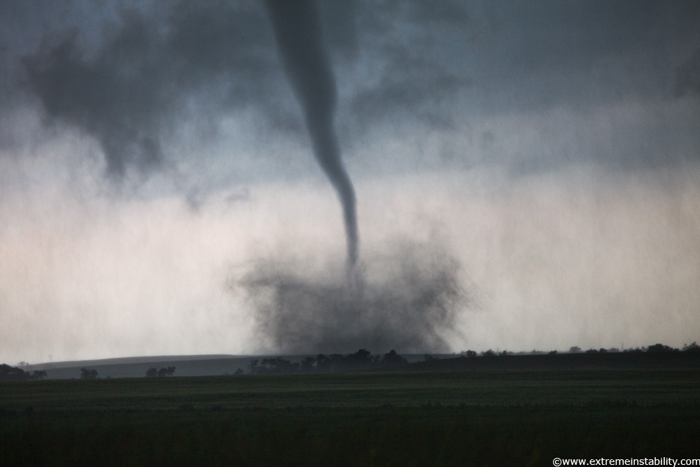
I sat here so long I started to get a little bored(or elsewhere intrigued), so I decided since it wasn't moving I could drive back west and sample the hail lol. And so that is what I did. I stopped not too far into it, so I could still see some hazy structure just south of me on this highway. Pretty soon I noticed just how strong the north to south movement in the clouds was just to my west. Afraid to miss something I decide to jet on back out of there, at 20 mph stuck behind a semi now. Larger hail began to hit. You could see that batch just starting to come out of some new area further to the east(from this storm, just a new area in the sky ahead of the core I'd just driven into). I was like, aw crap. Got out of it fine. Second I get out and get a clean view back to my south, hello, big curling rfd and tornado forming. Oh yeah it produced at least one tornado before that trip and a couple funnels. I shot mostly video this day.
I come right back to my little pull off. It's my pull off now, I've spent so much time with it. The storm is seriously in the same spot it was an hour ago. Evidently this was causing very serious flooding over this highway now. Some chasers end up trapped as they tried to come east through the core now. Foot plus of water raging over the highway. Then when they go to back track, it's now coming over the highway where they'd just come through. Looks like some vortex was shed off this storm too, which tracks right through where they are, snapping poles near them to the south and the pole ahead of them to the north! Yikes. Couplet showed up on radar with that. They measured 80mph winds with that ordeal. That is just crazy though, storm traps you there like that with raging water over the highway ahead of you, then new water behind you and tosses a vortex at you for good measure. Many storms love to do that with shedding mesos.
I mount my video camera and then strap on the 100-400L on my still cam and attempt handheld shots. This required 1250-2000 ISO and IS on. Like I think this one was around 200mm on a full frame and 1/60th of a second.
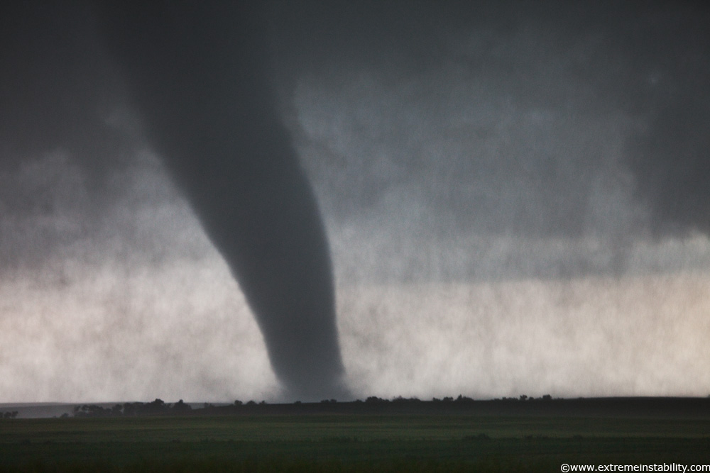
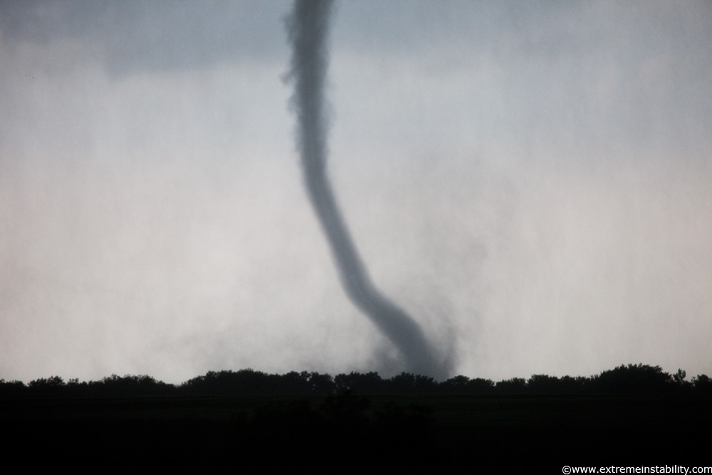
Good thing I didn't mess around in the hail too long! Doh. It became a rather amazing tornado to watch.
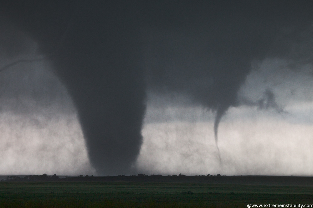
See? Another forms next to it and moves at it while this other funnel forms and fans around aloft on this side of it. You can pretty much watch this down coil deal before this on video form that thing. I think anyway.
A storm not moving produces a tornado not moving. I really wish I had taken the road south out of Dupree. Not sure what kind of road it was but bet it was at least paved for a while. I stayed up where I was all this time cause structure was better up there. But for sure the tornado view would have been better a bit more to the south out of this rain. I learned that stupid external mic I have for my video camera now is just a big sail for the wind. Video stutters a bit thanks to that thing and the strong north winds. Wish I'd learn that stuff on other days. At least most of it is fine and steady. Beats hand held video anyway.
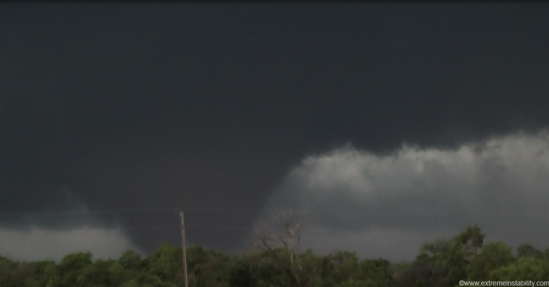
Kind of a drill bit now. At one point it goes flying east across the countryside at what I imagine has to be over 60mph. It simply crosses the hill so fast.
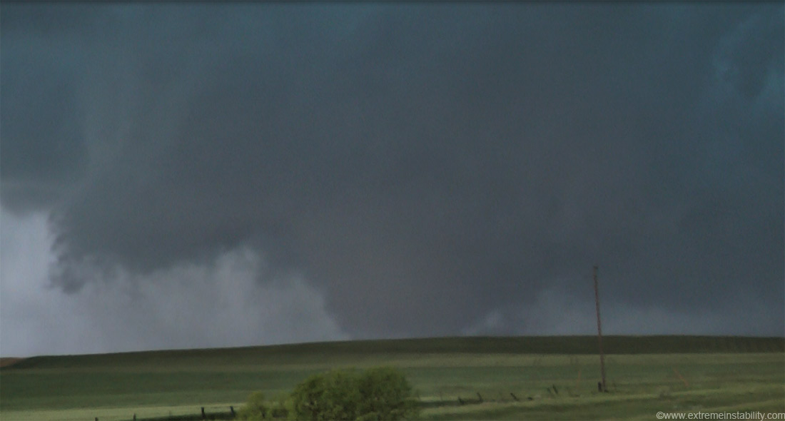
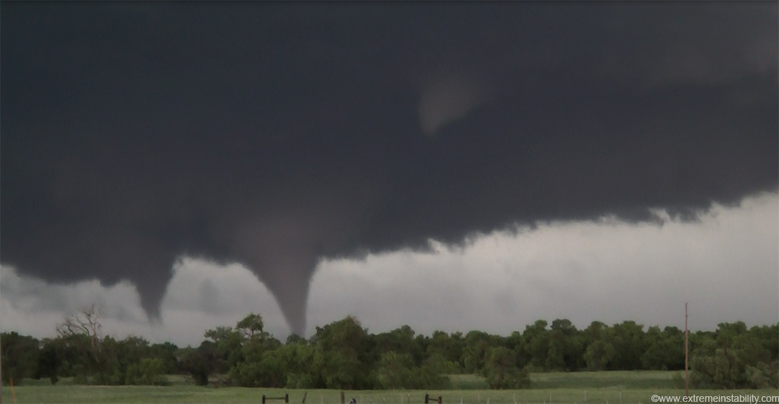
I am now east side of Dupree and the storm is at least finally moving some. More like just that big rfd moved and the anchor point back there stays the same almost. That last tornado ropes out south of me as I drive east and a new wedge formed where I was, this thing from a video capture above.
That turned into this cone probably in Dupree now. Another tornado had just formed just south of me here. I believe at least at first it was anticyclonic. The motion in the lowered area where it was was certainly anticyclonic. But you can watch all that switch on video. Soon it starts to reverse and spin cyclonically.
It now produces one high up funnel and two other tornadoes at the same time next to it. Those merge into another large tornado that borderlines on wedge but not quite. Another tornado formed after all that. The inflow at the base of the storm was sick to watch. It still took forever to reach me at this new spot. 7:02 now, barely east of Dupree. In 2 hours I moved from barely west of Dupree to barely east of Dupree. Hardly any chasers up on this thing either. Pretty much me and two tour groups for the longest time. Or does one tour have 4 vans now? Bob unfortunately didn't get east in time or want to punch it. I kept hoping his spotter network icon was stuck for some reason.
I'd rank this as a top 3 crazy storm I've seen. It might deserve top crazy for me. Just barely moving yet tossing out tornadoes all over the place, 3 significant ones. CG barrage check as well. Structure was so so. Inflow was nuts. It's crazy for the simple fact it was actually right on a highway out there. And crazy for not having a billion chasers on it by then, especially given just how long it took to get going and the fact it wasn't moving too. A few more cars were showing up by this time, but most of those looked like locals.
A lot better video of this event than stills. It's much like the Bowdle deal May 22nd in that way. I really look forward to making this year's dvd. Given I ever figure out the best route to do so with AVCHD files. Probably have to get Neoscene cineform to do it the right way. Got some serious white balance fixing to do at times, thanks to the auto white balance on this TM700 video camera being the worst I've ever seen on a video camera. It gets a hair up its ass and decides, eh, lets change from this nice grey to this crazy blue. Then next minute, hey, lets try super green now! The manual mode options for cloudy or sun just don't cut it. I need to figure out how to do the full manual white balance deal. Think you must stick a grey card in front of it and push the thing. At least the times it's going most crazy haven't been the most important on video, for the most part. That camera is easy to have a massive love hate relationship with. In one way it is amazing in others it drives you nuts.
Here is video capture of the 3 deal.
The lower left two merged into this.
A bit later from the same spot this deal forms.

This is from several stills shot facing the same way stacked later in photoshop. Like doing a real long exposure without the bad aspects of doing so. Clouds move too much over 6 minutes but there wasn't much structure to be seen here then anyway. The lightning at this point I think is probably the most wild I'd ever seen. Glad I shot video of it as I often don't with lightning. Some points it's flashing at what must be around 7 flashes a second.


