June 29, 2016 Persia to Neola Iowa Tornadoes
It's sort of humorous that I haven't had a storm intercept overly worth posting for nearly a year and it finally comes on a Storm Prediction Center "no tornado risk" type of day. A couple have been close but mostly only slightly worthy and mostly on the video side. I did do some night photography that I should have made a page on, but I've been side tracked working on some other "past events" deals, yet to get posted. I have spent a silly amount of time on those.
I'll probably make a page that in a round about way details partly why my year has been my worst to date to this point(I still have hopes for summer). Basically I really don't care for the super crowded days, but haven't totally written all those off either. That is always one aspect though. I am more than willing to blow off early to have more funds for later. The other is well funds. The third is my car deciding to suddenly have starting problems, right in that stretch in May. I'd get gas somewhere and then it almost wouldn't start. Then for days you'd never get it to repeat. Then on another chase, hey it does it again. Wound up being a starter going bad. I also had steering noises and problems and had to replace struts, tie rods and control arms. Then bump steer as I needed it aligned. I also have 2 bent wheels that cyclically vibrate the car over 60, that is still there and only moderately annoying. Stuff that makes driving far, on half questionable days, to be with a million others, while also not having money to do so...pretty hard.
The other aspect to this year is those days in May, that just went nuts, well almost none looked nuts ahead of time. Wray tornado setup was pretty dang dry, but that storm pulled it off. I almost went Leotti KS day but car and well it wasn't that clear cut going to be great. Seems the Dodge City day was one of the more solid no-brainer days, but given numbers I just didn't overly care. Holding off for later sounded fine. Then there's that 90 minute tornado day in KS. Low level flow was going to be weak, with models only showing 15-20 knots at 6,000 feet. Seems it was 25 on Topeka's sounding in reality...close. I almost went that day, as by then I at least squared away half the car concerns. I then felt, well it seems safe to hold out one more day. Nope. Everything in that stretch just found a way.
Then comes June, where I'd hoped to be able to chase a bit. I sure don't remember a worse June. I did get a supercell southwest of Sioux Falls on an almost no risk setup, which then turned into the worst, longest windy drive south, ahead of a subsequent line. Almost post worthy. Then after that, a couple days before this one, on another low low risk deal, I got a supercell in southwest IA then severe winds with hail. Almost post worthy. There was a severe hailer in NE after KS on one of those car starter problem days. Really only some video.
So here for the lack of accounts forever, is an overly long one.
If there's juice, a boundary and some flow in the mid to upper levels and it's within 3-4 hours, I'm almost always interested enough to go this time of year into summer. I go on these so many times. This one just happened to be super close. I never see them work out here though, always ends up in the central NE/SD areas.
All those things were clear on this day in the morning. Models showed the flow. There was a crazy derecho wind event the night before in western NE on south. That one wasn't forecasted, with only a slight till 3pm if I remember right. Then an 8pm upgrade clear to moderate, with more than one station recording winds over 100mph already. But that complex cleared out the air there on south, while leaving the air here pretty much alone. There were some elevated morning storms that move through and out. Those did overturn the air in IA a bit. It was pretty clear that between those two, the air would be good to go. So as a chaser, 2 super important parts seemed good to go.
The surface pattern was a big mess though. The only thing somewhat clear, was a bit of a surface trough in eastern NE. To me it seems this is where the outflow from the night before had pushed east to. Sort of opposite of a typical behind it setup. It's also where the elevated eastern morning stuff cooled the air on the east side of it and was arcing back north from eastern KS. It seems there was a bit of a pinch that arcs up to where this storm goes. Sure seems that surface trough extension in NE goes up west of it though.
The HRRR model was very much catching this mid-morning. Two runs in a row it popped up a supercell and tracked it straight down the river for a few hours. But then after those two runs, it completely abandons that idea and just has a mess of small storms. Anyway, soon as I saw the first early blip pop up in this area, I left to at least get out and watch. I sat like 5 miles from home for an hour or more, with strange bugs attacking me in my car. Ok they weren't attacking me, but they kept bouncing off the car or coming in the window. That first early wee little blip vanished before I even got over there.
The thing about that early blip(barely can call it a blip, like 10dbz probably) is those tend to readily tell you exactly where any maximized surface convergence is. It sure wasn't findable on a surface map that I could see. Seems it was east of what surface trough there was in NE. I started to think nothing would ever sustain, because of this apparent lack of real convergence. Low level flow being pretty weak not helping. But at least that tiny hint at convection early pointed it out and it was nearly where the HRRR model had been keyed in.
Then some "real blips" finally start to pop up, much later than that first one. They weren't much and would take forever to organize. Tops not even breaking 30,000 feet on radar. Once they did though I decided to move towards them. Wound up taking the road I saw my first tornado on west of Logan. I may have only taken that road once since that time in 99. The storm was small but man I thought it was going to drop a tornado the whole drive towards it, as it had a pronounced wall cloud.
This is now probably a half hour after reaching the storm. I was on it north of Woodbine but it wasn't much yet. That and the photos I took the focus was off. Problem was I just replaced my last chase broken window clamp. I wasn't smart enough to make sure it was all ready to go beforehand. I grab it and hey, I need an adapter to screw it into the quick release. The quick release 1/4 to 3/8 adapter having stuck on the old bad one. It never occurred to me till later I could have just taken the mount off the bottom of my camera and threaded it on for now lol. Man would I really really miss that window mount on this chase. But anyway, to shoot video I had to keep setting the camera down, which would easily bump and move the focus ring on the lens.
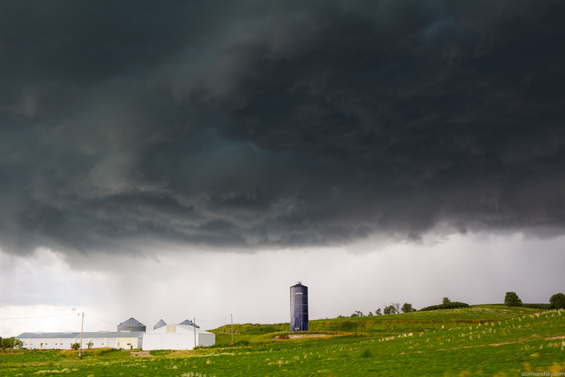
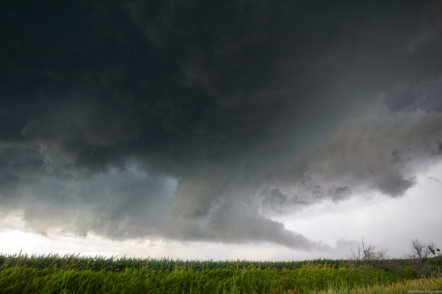
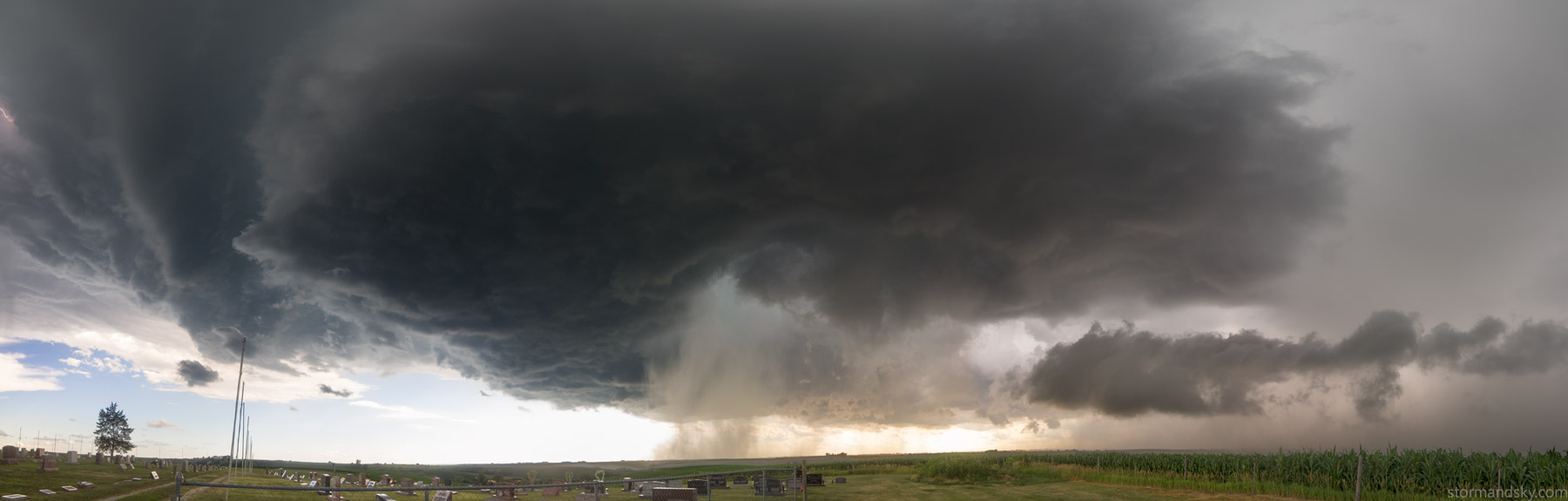
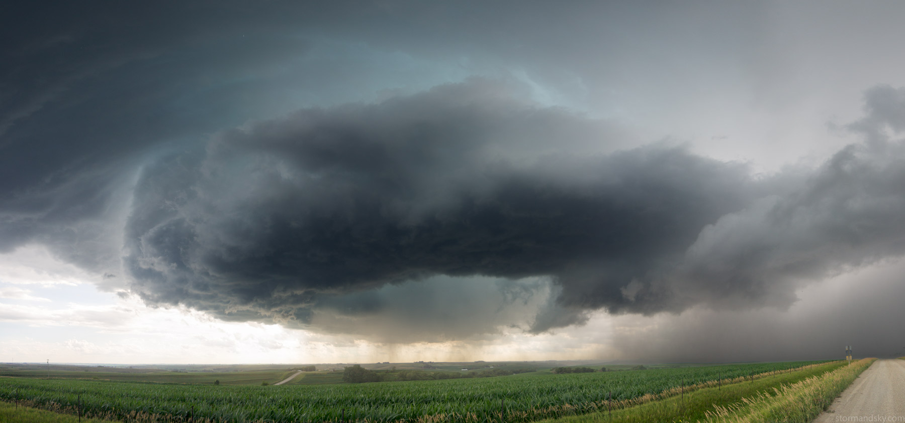
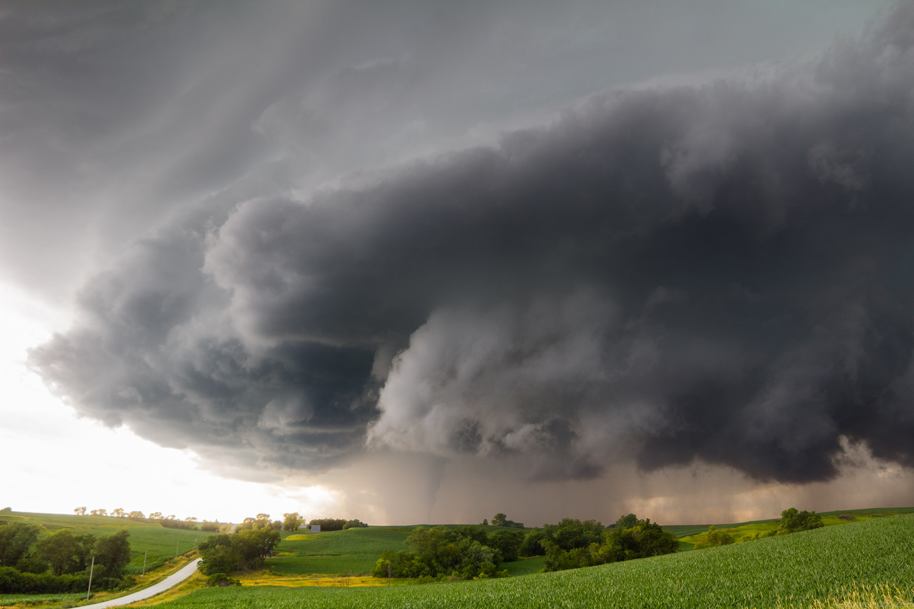
So there's nothing on here before it gets to Woodbine but that is ok. It did have a shed white funnel before town though. After that, while dropping south to Woodbine to go east of town, I noticed a second base east of the other. There were really two entities before town. Well I could see that base and the west one were in the process of merging. Given outflow wasn't just already surging out and going ahead of everything, and this base merger was happening like this, I knew something at least more legit was going to form. The environment was saying right there it would. The above image is then. You'll see on the radar loop how they were two and tiny before Woodbine.
At the very start of this radar loop, towards just right of upper middle, you can see the tiny two entities before merging happen. Then well she forms a hook and goes southwest producing a couple tornadoes! Interestingly at the end a storm pops up in southwest Omaha ahead of this and does the same thing, minus tornadoes. It was on the eastern NE trough or old outflow push. I don't see how this one in IA could have been right on the same thing. I'd think shear and thermodynamics balance just dictated this southwest component more than some boundary would. Anyway, back to the start. I would get on that southwest Omaha storm too.
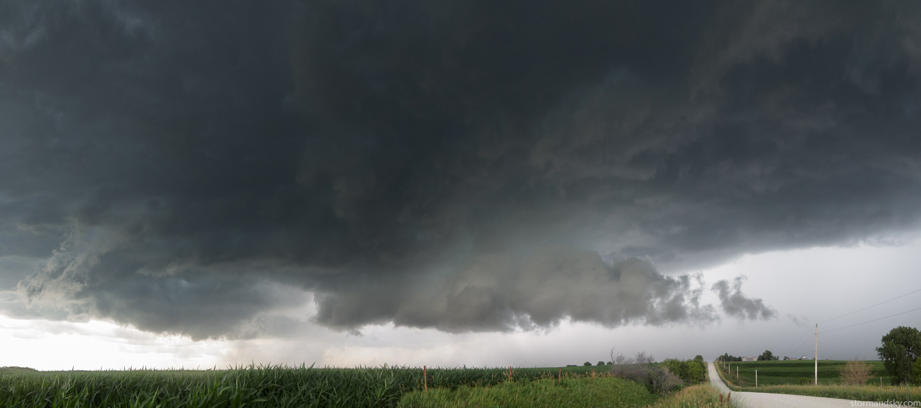
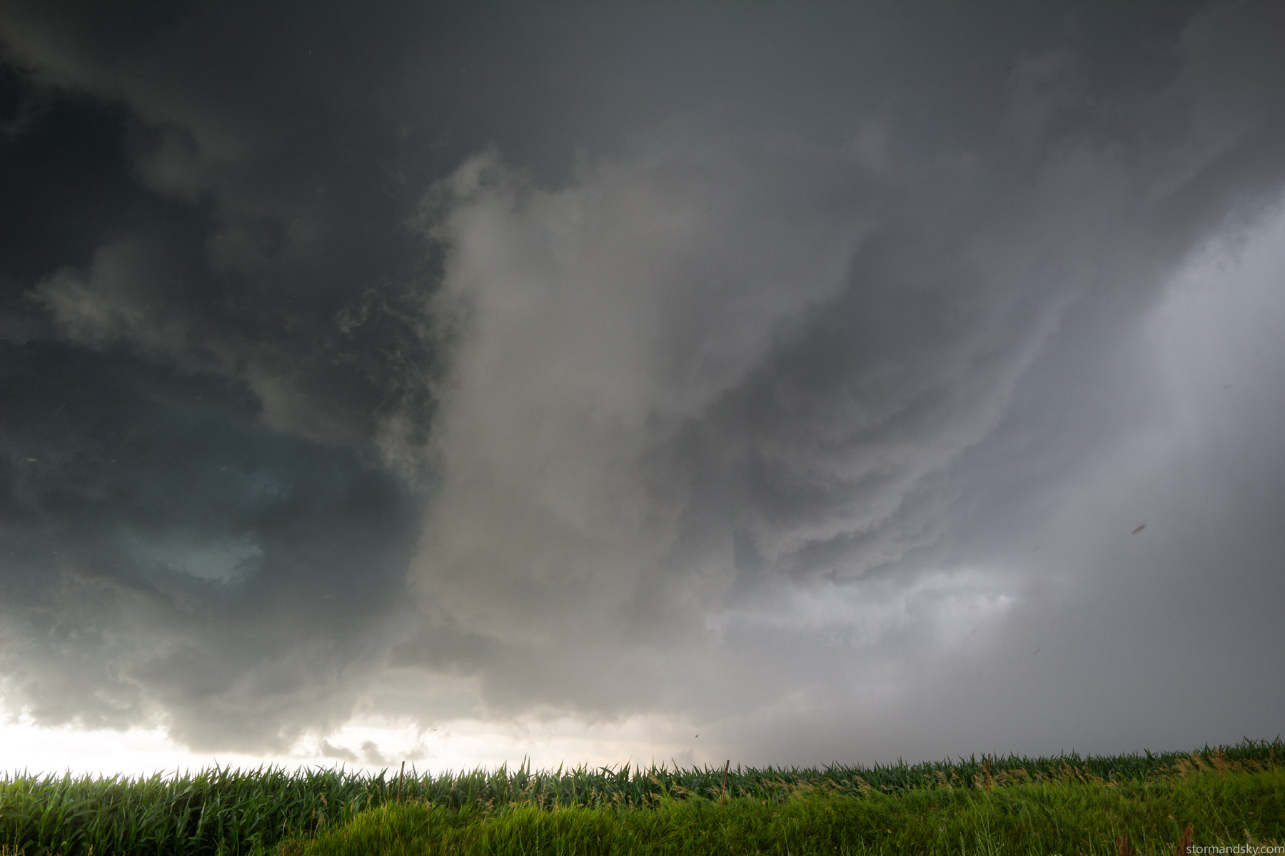
Just east of Woodbine, south of that highway. Merging bases with a nice rfd cut. She was clearly getting undercut some, but this right now was amazing for me this year. I'd go out on weak setups, just hoping for marginal looking shelf cloud, only to not even get that to happen this year. It got bad. This was like, holy crap a real storm!
Things getting more real now, as I begin to think she is going to deviate and go southwest, helping the storm relative shear.
Things getting super real now. On a radar I'm right in the notch and right up against the core, the core that would head southwest. Well the motion in that core got pretty silly right here. Very strong motion blasting southwest. I'm an all types of storm guy. I don't need tornado or structure photos, just experiencing a core works. But only if it is a good core. If I'm going to have broken windows, it needs to not be by golf balls. I also don't want rain ruining roads and ending my chase and missing what comes later too. It's a pretty tricky game to play. But the point is, right here and now I truly wanted to experience what must be happening in this surging core, going off how intense it was looking. But I skip out to stay with things. For now. I did let it get me some once, only included in the video at the end.
Go south some and stop and hey, she's looking good.

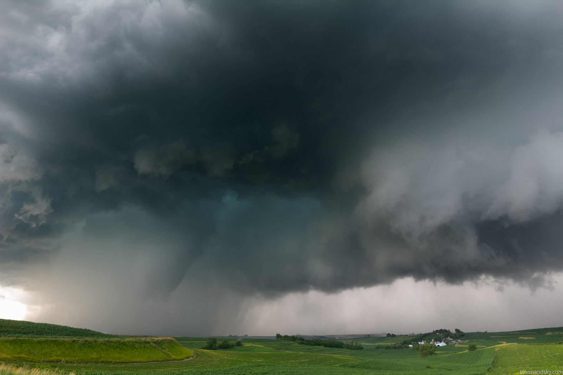
I sold almost all my gear this year and am no longer full frame. The 14 and 24mm just aren't the same on crop, thanks to the 1.6x factor. So capturing the full storm while also being very much right on it, requires pano or multiple frames. I think I put the 14 on here and took several vertical shots. I guess I also moved again. But you'll see how sort of crazy the same lens and camera can make things look from the same spot and time when just used in pano.
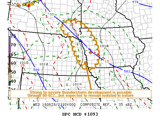
   MESOSCALE DISCUSSION 1093
   NWS STORM PREDICTION CENTER NORMAN OK
   0536 PM CDT WED JUN 29 2016

   AREAS AFFECTED...ERN NEBRASKA...WRN IA...SERN SOUTH DAKOTA...FAR
   SWRN MN

   CONCERNING...SEVERE POTENTIAL...WATCH UNLIKELY

   VALID 292236Z - 300030Z

   PROBABILITY OF WATCH ISSUANCE...20 PERCENT

   SUMMARY...ISOLATED STRONG TO SEVERE STORM DEVELOPMENT IS POSSIBLE
   INTO THE 00-02Z TIME FRAME.  HOWEVER...THE NEED FOR A WATCH IS NOT
   CURRENTLY ANTICIPATED.

   DISCUSSION...RELATIVELY ISOLATED BUT VIGOROUS THUNDERSTORM
   DEVELOPMENT IS ONGOING ACROSS PARTS OF THE MID MISSOURI
   VALLEY...MAINLY NEAR/NORTHEAST OF THE OMAHA AREA.  THIS APPEARS
   LARGELY IN RESPONSE TO LOCALIZED WEAKENING OF INHIBITION ASSOCIATED
   WITH INSOLATION...ALTHOUGH IT MAY AIDED BY WEAK LOW-LEVEL WARM
   ADVECTION.  MID/UPPER SUPPORT FOR ACTIVITY...IF ANY...REMAINS
   UNCLEAR.  HOWEVER...IN THE PRESENCE OF THERMODYNAMIC PROFILES
   CHARACTERIZED BY MODESTLY STEEP LOWER/MID TROPOSPHERIC LAPSE RATES
   AND MIXED LAYER CAPE UP TO 2000 J/KG...VERTICAL SHEAR BENEATH 25-30
   KT NORTHWESTERLY 500 MB FLOW APPEARS AT LEAST MARGINALLY CONDUCIVE
   TO SUPERCELL STRUCTURES.

   AT THIS TIME...IT APPEARS THAT THERE MAY NOT BE MUCH MORE THAN AN
   ADDITIONAL STRONG/SEVERE STORM OR TWO THROUGH EARLY EVENING...BEFORE
   THE LOSS OF DAYTIME HEATING CONTRIBUTES TO WANING CONVECTION.
   HOWEVER...IN STORMS THAT ARE ONGOING OR DO CONTINUE TO FORM UNTIL
   THEN...OCCASIONAL SEVERE HAIL AND LOCALIZED STRONG SURFACE GUSTS
   WILL BE POSSIBLE.

   ..KERR/GUYER.. 06/29/2016
The SPC did issue an MD right now for the area. One doesn't always get a watch with tornado producing supercells. This one was happening without any watch at all, not even a severe was issued. If only there was a solid way to tell when something is going to go deviantly right. This storm was merging and turning right as that was being written.
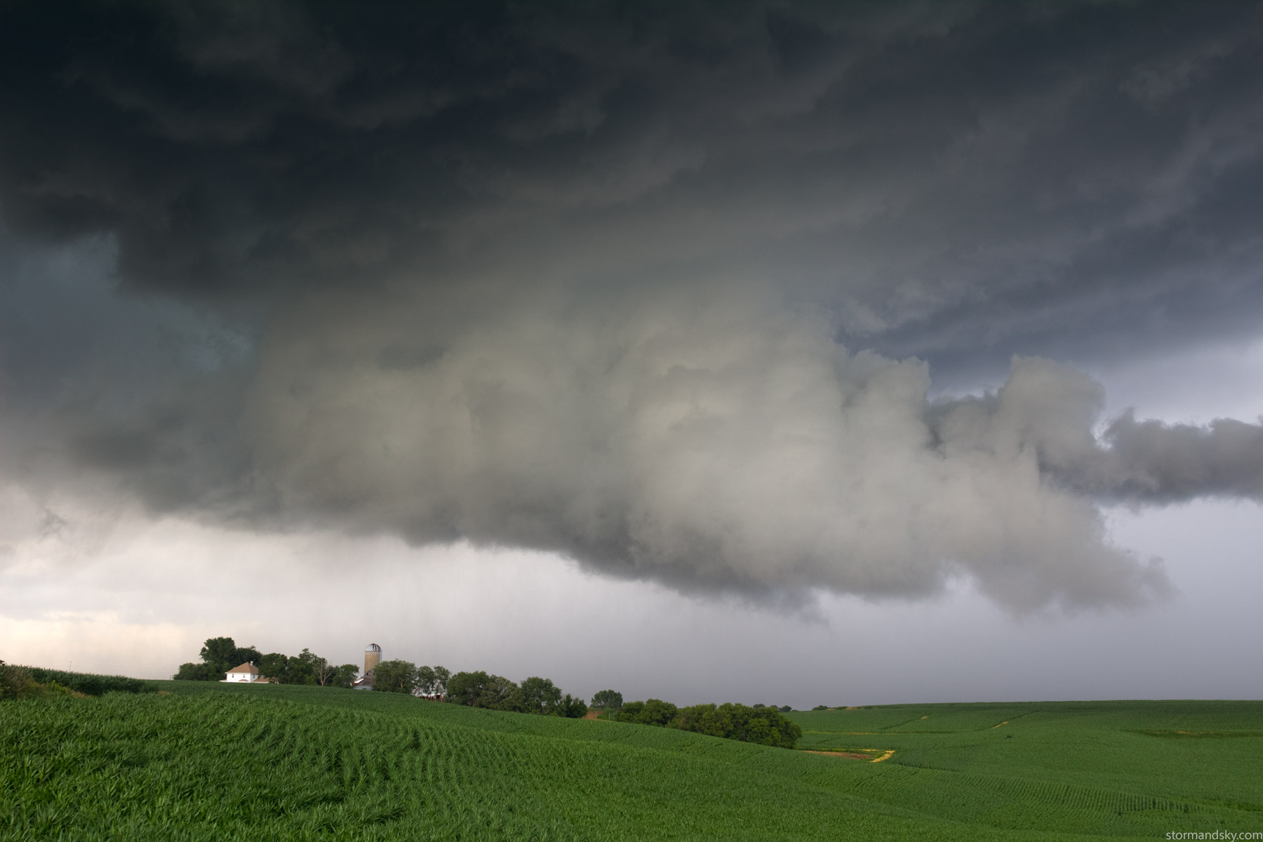
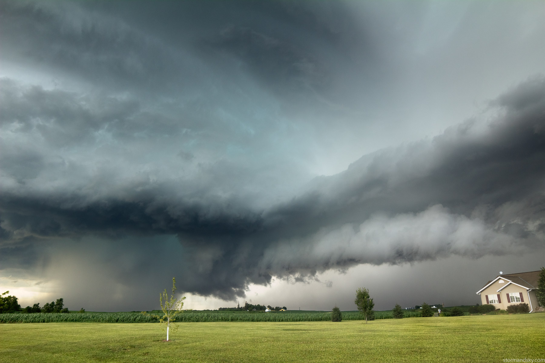
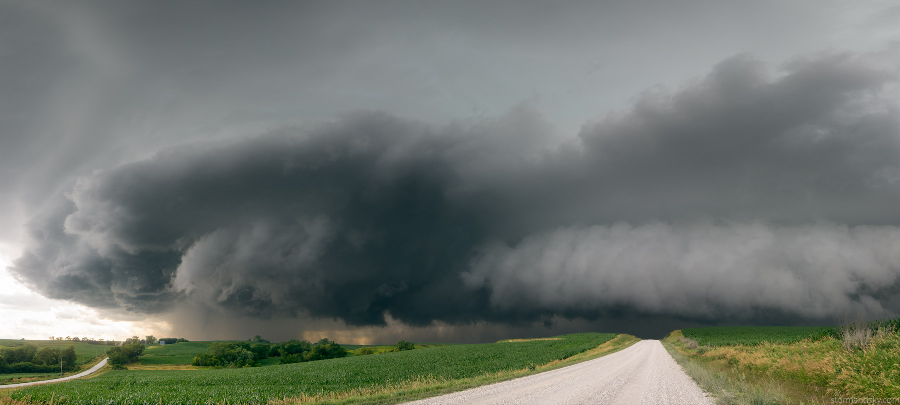
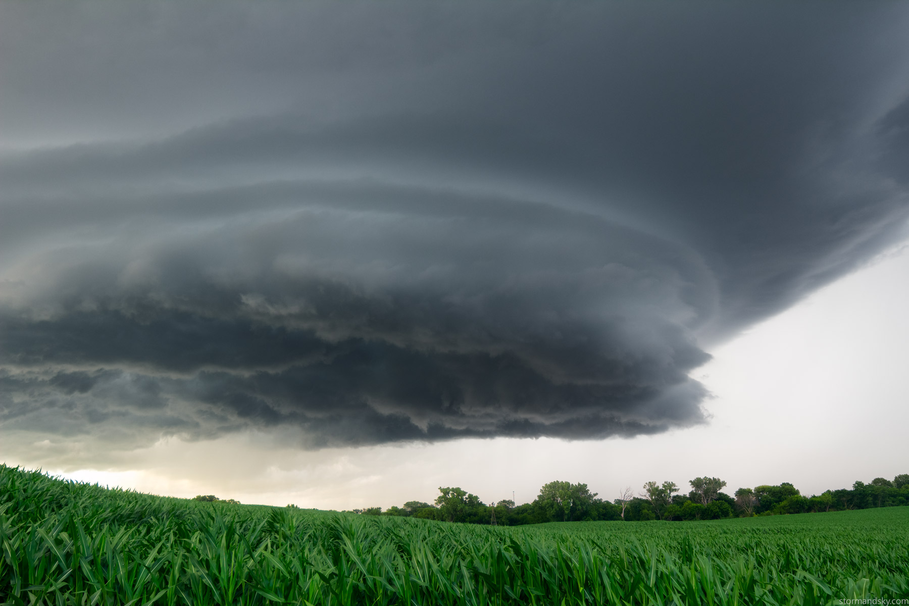
Moved south some more. Roads being great so far. This should be the cemetery west of Persia now. Nice open view with a now highly circular base overhead. When I say overhead, I mean overhead. This is the 14 turned sideways for several shots again. The corn on the right is north, the poles in the cemetery run south.
Since I didn't have use of a window mount(maybe the first time in over a decade) I was having to toss an extended tripod in and out of my window. I don't get out in lightning. I didn't even like reaching out to mess with it, given the bolts coming down. Look way way left on this image, just snapping the frames for the pano I caught a bolt. Sucks that in the actual frame for that it's fully in the shot, but after stitching it has to be cropped out.
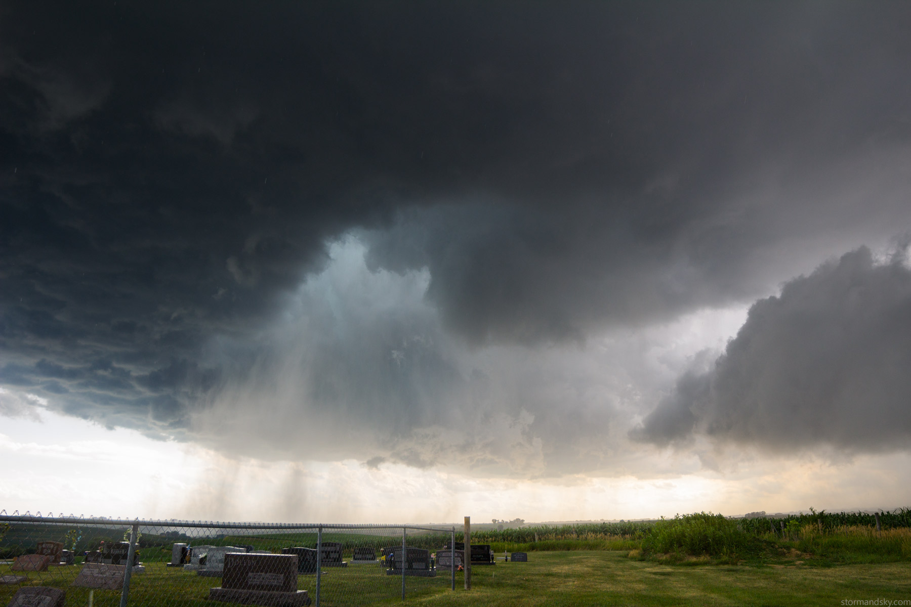
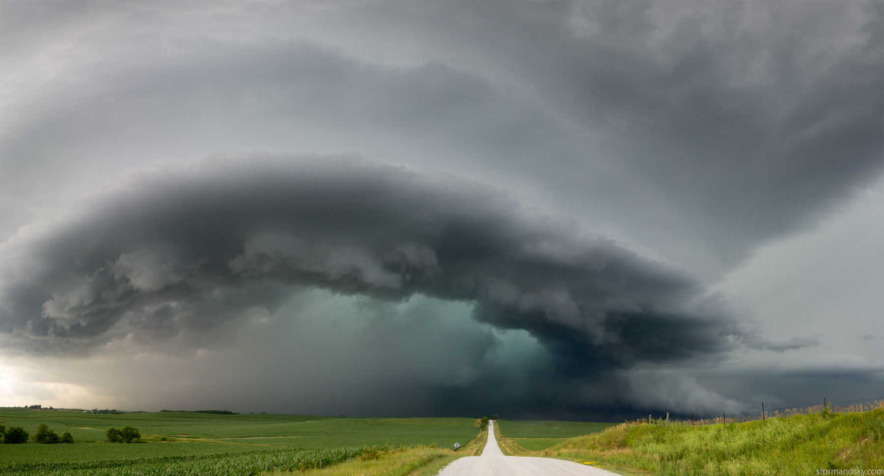
This is the same lens used on the image before, just one horizontal frame. That's how not wide 14 is on a crop body, sigh. The thing about this structure right now was, I was 100% certain it simply had to produce now. The way it is curled and cutting in like it is, it is as if a storm crossed a point it can't return from without a tornado forming. Like it is set in motion and will simply happen now. I say as much on video at the time. I'm realistic yet right then I simply had no doubt it was going to produce.
So right now I know it is going to tornado and I'm decently close with a good view. I'm set right. Boing, doing, dink, donk. Rain and hail. Like crap, core starting to move over already. Do I hold out a few more minutes and deal with that or just get going. It could take a bit longer and there be too much core happening on me to see. I mean my video camera was completely backed out wide and while including any foreground at the bottom, I was only scraping the base where the tornado was trying to form at the top. But had to leave that spot and drive and did.
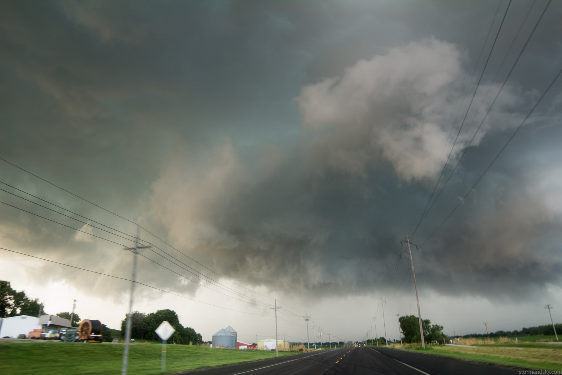
Knew it was going to tornado. Crappy part is I could tell that 10 minutes ago though. Had I just left right away, I could have been right with it. Right here as I get view of it, after dips not giving me a view, I go right on back down a dip. I hit a T, with only a view of the top half of the tornado. Neither way looked obvious for gaining a view. I took the north one that would soon let me jog back west.
I then hit a T again and jog south, hitting a right curve soon after. This was the view then, right before hitting a left/south curve. The roads had rapidly gotten annoying after leaving that cemetery. It's to be expected in the Loess Hills though. It's a notch less annoying than say northwest Missouri chasing, but not massively.
Some zigzaggin later in a nice open spot for 1 minute. My roads kept forcing me to jog back east instead of west. The "mile grids" in this area have been replaced with "Tetris grids." The storm was going southwest. It made that 15-20mph storm motion feel more like 40. The structure now after that tornado made me wonder what it looked like from ahead. It wasn't making me think tornado that much now. But hey.
I get across the interstate and jog west and can see it is wrapping up a tornado again. That point in there up and left of that small tree in the yard.
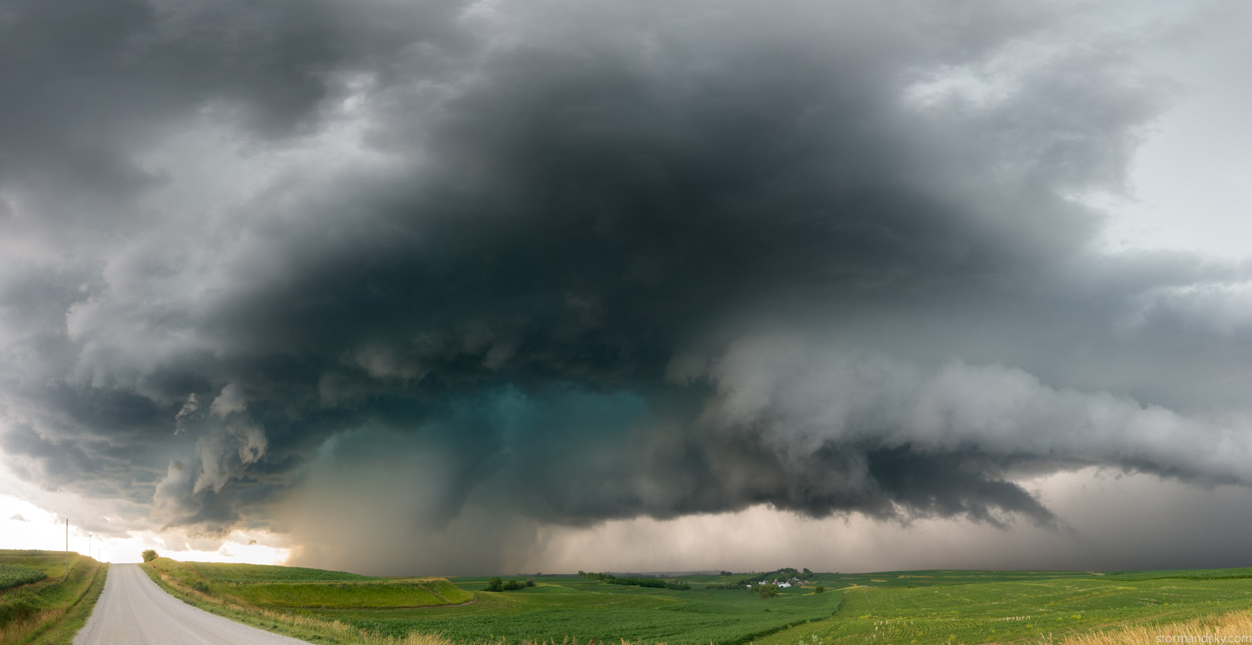
At least a 90 degree pano here. I'm sort of glad I'm stuck with 14 on crop for width and forced to do these. They also get pretty damn high res when doing it this way too.
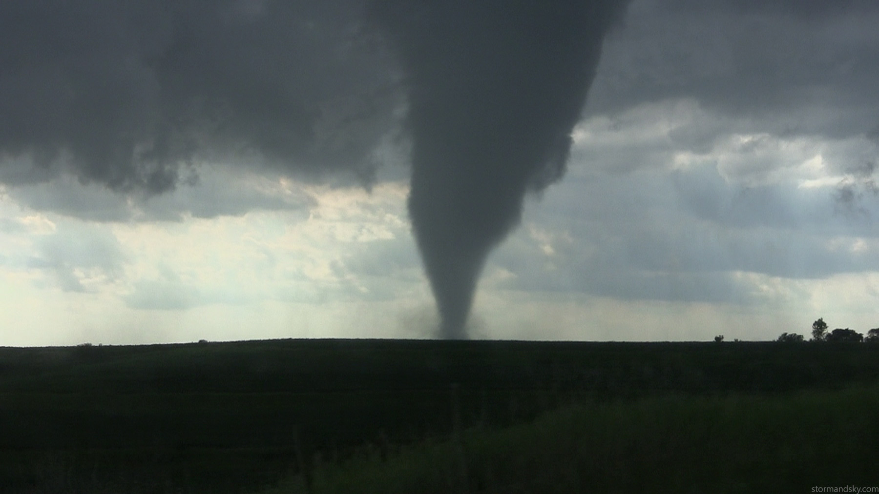
Pretty legit sized cone in there that is surely on the ground in some form. This has to be really close to being on I80.
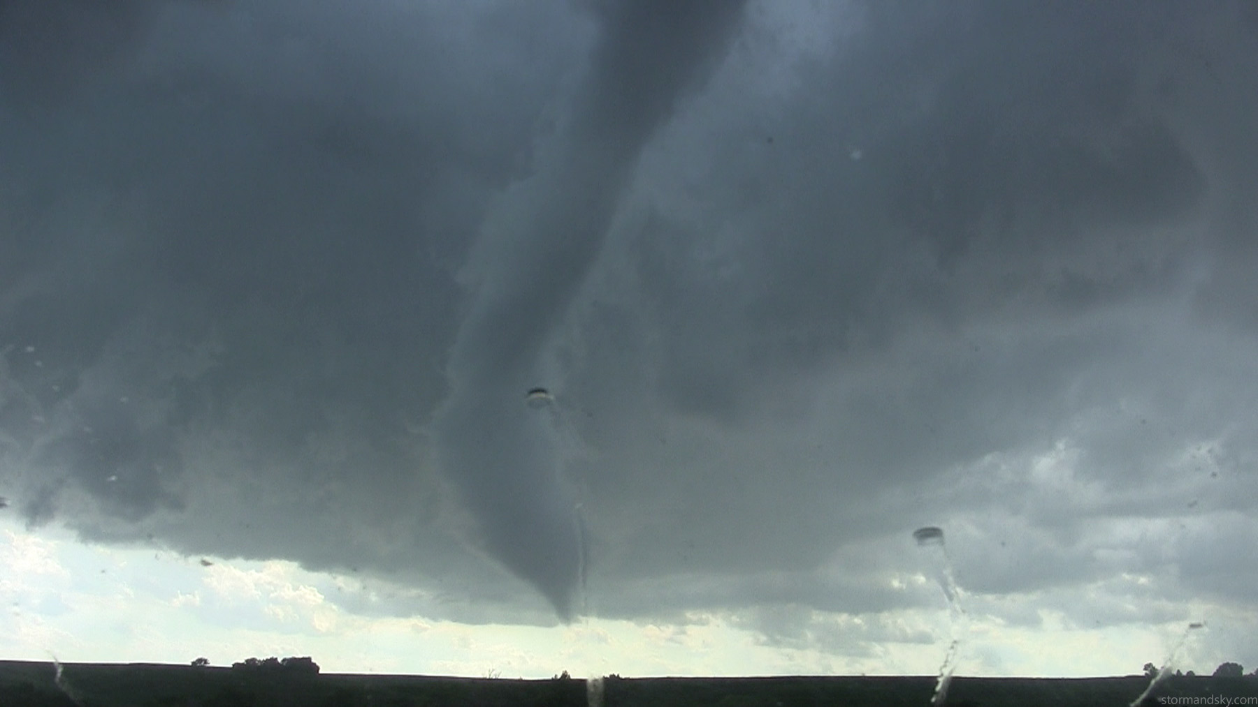
I drive some more, losing that in the rain. New rotation kicks in to the east of it. I then notice a nub funnel in the rain, not appearing on the ground. It then tightens up into this tornado. I at the time thought it was number 3, but am rather certain this is just a continuation of the other.
A lady pulls up here and informs me there is rotation north up this road, all the while this tornado is right behind her. As she moves past and stops I informed her, well there's a tornado right there in the rain. I think she leaned up out of the car and looked back and said something to the effect of "aw crap" or "aw shit" and moves on.
This road goes north, that distant one west. Again here it is pretty crazy how a few frames can make things look. I'm 99% certain this pano I used the 14 vertical again and used the same lens and camera on the one before. This makes it look really far away but just look at the image before and realize that is the same lens and camera and it is a wide 14. It's actually closer now in this pano than the shot before.
I finally get west ahead of it and realize I was better off being east of it more. It sure looked capable of producing in there in the rain still. Right left of the road there.
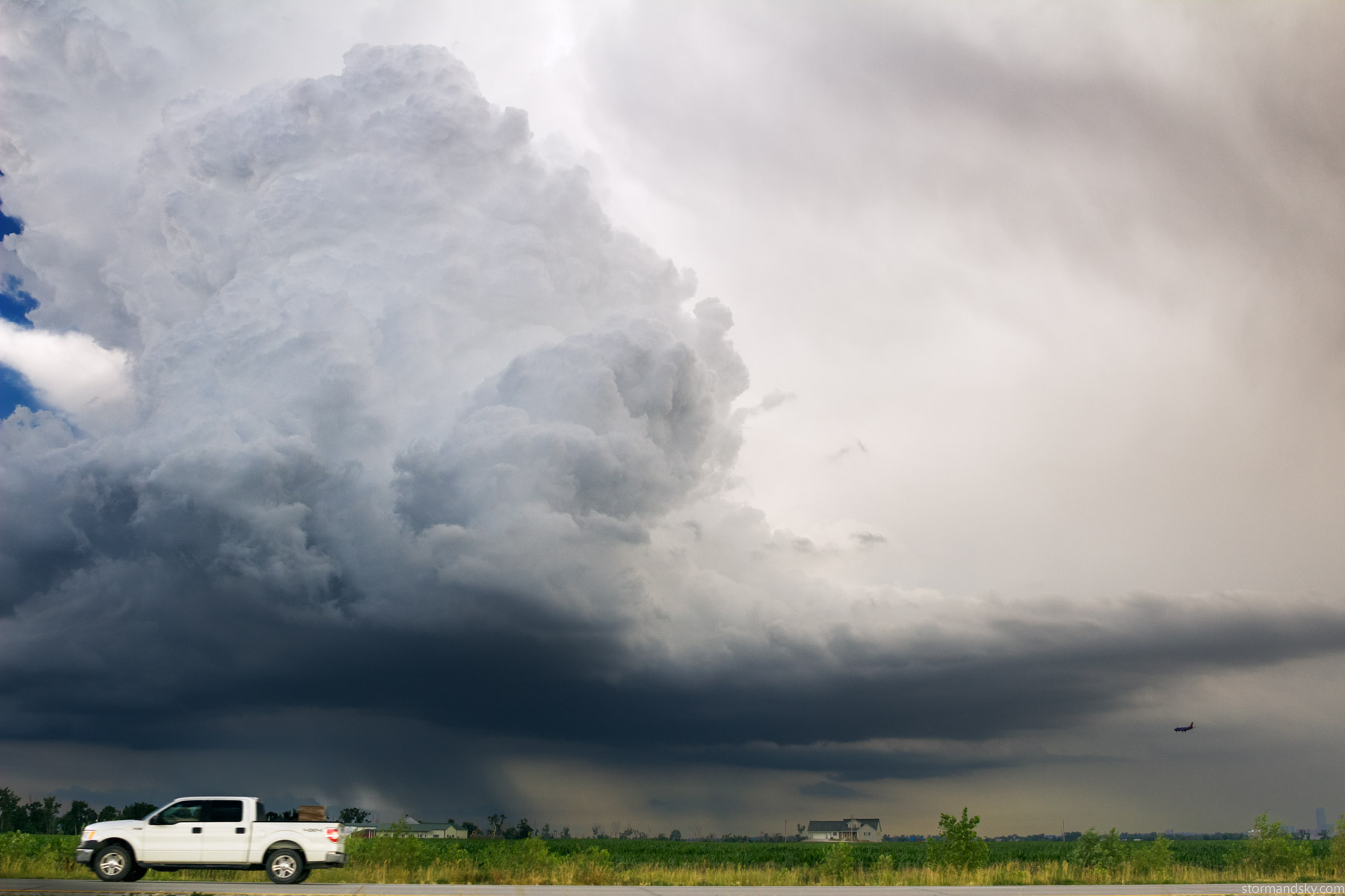
It was soon apparent that it was going to die soon, so I headed west into Council Bluffs. As I drove into north Omaha, the convection popping up in southwest Omaha got the better of me. Thought, heck it ain't far, I better go look. This updraft here was something else more east in Omaha. It looked a hair crisp. These would do that down lower, but not so much higher up on this day. Planes flying into Eppley below it made it seem more dramatic. The cell in southwest Omaha called me though. It acted more rooted on radar and was ahead of the surging outflow boundary off the previous storm.
What I could glimpse up and out my window, as I drove I680, was something intense was happening above me. Still not from the storm I was headed to, just some other updraft. Without looking I held the 24mm over there for a few frames till finally getting it, the updraft exploding out horizontally.
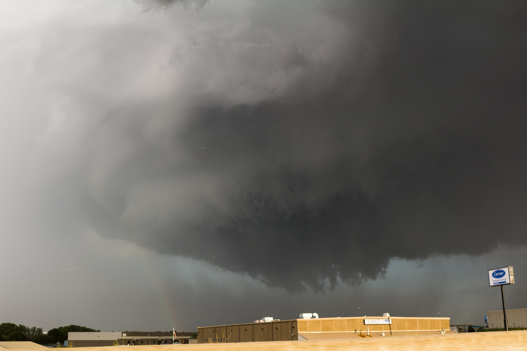
Cruising around southwest Omaha on I80 now, beginning to encounter the target storm. Right away I was thinking, holy crap this is going to produce too. It sure was wrapping up and trying now. I was in traffic and some rain right now and not overly able to look at my gps. I should know the area enough though right. Was scratching my brain, what do I want. Saw the sign for the Gretna exit and thought, oh yeah that south works. Forgetting in that very brief moment to decide, that there was a Gretna exit before the one I wanted, which runs e-w. As I was taking it I was also realizing this was not what I wanted, but I was on it now. Took the left realizing the actual exit I was on and then took a second to glance at the GPS. South to Springfield was right here! How to take exactly what you'd want to take on complete accident lol. I'm not sure I've ever been through Springfield. And I used to work in Omaha driving HVAC stuff. This image accidently having Carrier in it makes it somewhat ironic. I was aware of the more lame terrain tendencies getting near the river there though.
South of Springfield now and it was sort of meh. It had that I'm never going to produce tornadoes now look anyway. It wouldn't completely keep that though and somewhat teased it in the rain.
I saw signs for one lane construction coming into town that said till 7:30 or something and it was after, going on 8. Never encountered any. I then play with a teasing rain area, getting up in it, only to then race back south. I then turned south, soon hitting one lane construction with cars stopped, sigh. The storm was about on that spot. The side of the storm that if it were to somehow produce or be producing wrapped in there, was going to move right over this spot. My quick gps glancing looked bleak. One crappy road that only went west so far and the river blocking any east move. This stop was right before crossing the river south. I thought, I don't like jumping on this gravel thing I can see winding up a hill to who knows how far. Was decently sure it currently wasn't producing a tornado. So I thought, ok, guess I'm going to just plow right into it now. I no longer have any desire to do that on supercells. Too many no fun times in windy cores wondering. And here was another. It got damn windy and hard to see. They were hard from the east though. I was like, please don't change. It was damaging trees in Springfield and knocking out power. I didn't care that I was ending the chase doing this, as I was rather ready to head home now after some intense driving for 3 hours straight.
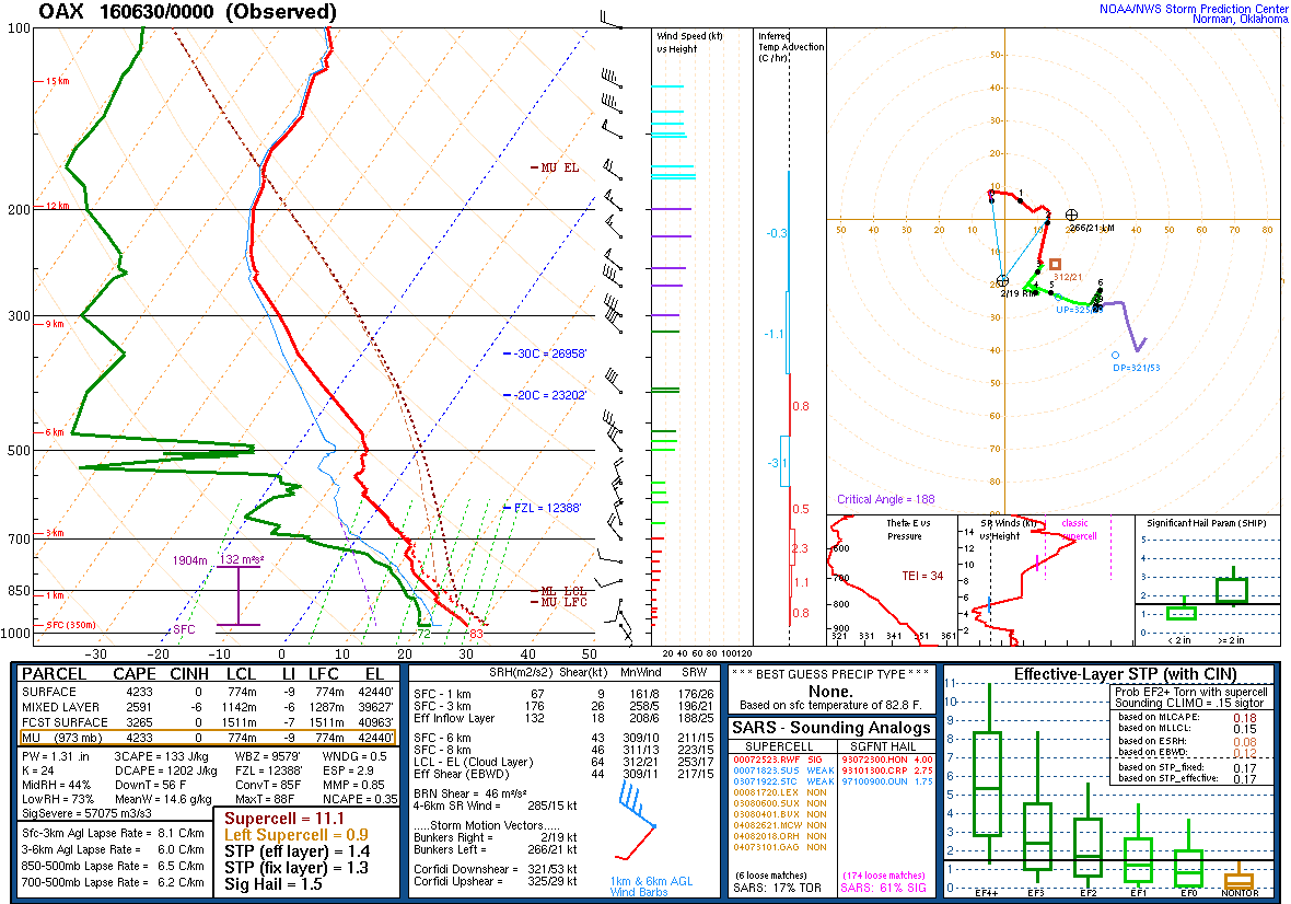
Here is Valley's actual sounding from 7pm this evening, which should be pretty representative of the atmosphere on the IA storm.
Here is the satellite loop for the day. Mostly all one can see is the eastern NE trough that shows up barely west into NE as a north-south edge to that cumulus field. That stretch at least showed up on surface obs with some very weak convergence. The Omaha storm at the end pops up on that.
Some video of the event. This is as much a documentation of the road choice fun as anything.


