June 9, 2003 nc Nebraska Tornadoes
.jpg)
What a day is all I can say. I got off work at 1:30 and headed nw towards the sfc low. There was moisture surging north in sc NE at this time. 40-45 knt west flow at 500mb atop 15knt se sfc flow. The view here is looking nw to the north of Atkinson.
.jpg)
Watch how the dry slot wraps around the front of the storm. Also notice the detached beavertail thing going on to the ne.
.jpg)
Slot moving further around as a visible vault takes shape. There was lots of motion in the lowering for close to an hour before the first real tornado. I heard the report of the very first dustwhirl nader but could not see it from my vantage point.
.jpg)
Still wanting to tube but not getting it done.
.jpg)
I moved back west then back south to Atkinson and viewed the tornado for about 10 minutes from start to finish.
.jpg)
Nice slow moving white tornado.
.jpg)
I was viewing the tornado under the base of the new storm ahead of it. I could see a notch cutting into the updraft as the tornado continued well nw of me. That cut slices in very hard and soon I'm in the strong winds at the surface. The area north of this cut, on this new storm, starts rotating rapidly ne of me in Atkinson. I'm viewing it here on the se side of town.
.jpg)
You can see rfd winds blasting dirt to the east here and a lowering on the left side of the picture.
.jpg)
The area north of the notch continues to spin faster and faster and moves this lowered funnel shaped cloud to the center.
.jpg)
That funnel shaped cloud moves to the center as more and more updraft gets piled around it. At first it is sort of at the tip of the curl, but as it continues to cut it keeps going towards the center. It is really hard to see what I'm talking about on these video captures.
.jpg)
I get back on the highway and head se towards O'Neill. Not long into the journey you can see something is on the ground now. If that ain't a wedge I don't know what it is. It was rather hard to know if it was a tornado of if it was just rfd dirt. Some contrast and other views show it was most certainly a very large tornado. NWS damage survey has this at 1/3 mile wide at one point.
.jpg)
The right edge of the tornado is close to the right edge of this image.
.jpg)
.jpg)
.jpg)
Dust getting kicked up further south along the rfd.
.jpg)
.jpg)
.jpg)
It got rather jaw dropping from here on....like it already wasn't I guess.
.jpg)
Just look at that thing! What a monster. The mesocyclone is now basically on the ground.
.jpg)
.jpg)
.jpg)
Easily the coolest storm I've ever witnessed.
.jpg)
Sort of a difuse 'tornado' now.
.jpg)
.jpg)
.jpg)
.jpg)
Sick storm with sick motions, chewing up a piece of Nebraska. I would really like to know why I was not shooting stills during this!
.jpg)
Yep...sick. LCL's lower a lot right now and they do so very quickly as rain/hail cooled air begins to wrap around the strong circulation.
.jpg)
You can make out the outline of the something in there, just nnw of O'Neill.
.jpg)
Another satellite. We are nearing O'Neil at this point, at the storm's strongest point.
.jpg)
Driving into O'Neill right after this was a bit spooky. These wrapping rain curtains looked to head right into town.
.jpg)
Sirens blaring in O'Neil as rapidly rotating rain curtains approach us to the north. Had you got caught within the outer circulation, you surely would have had no visibility. Steve Peterson passes me here and can be seen in the pic. I lagged back to the end of the convoy of chasers in awe of what was going on just north of town. I think O'Neill was very lucky.
.jpg)
Raced se of O'Neill for some structure shots.
.jpg)
We had 50-60 mph inflow gusts during this.
.jpg)
The sky at the end of the day's show was unreal all by itself. These colors are not altered.
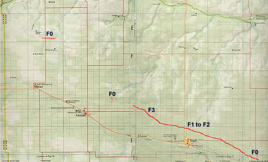
Damage map via North Platte NWS.
Notice how long that path is. I wonder how long that is as they do not say on the NWS page. 15 miles? Probably about that, maybe a little less. I don't think that storm exceeded 30mph. That'd be a good 30 minutes on the ground. Notice the first tornado was up north of Stuart. I shot video of that from Atkinson, well to its sse. That second F0 on this map happened within probably 2-3 minutes of the end of the Stuart tornado.
More pics of the event here...
http://www.crh.noaa.gov/lbf/pastevents/jun0903/images/holt_tornado/index.php.jpg)
.jpg)
.jpg)
.jpg)


